
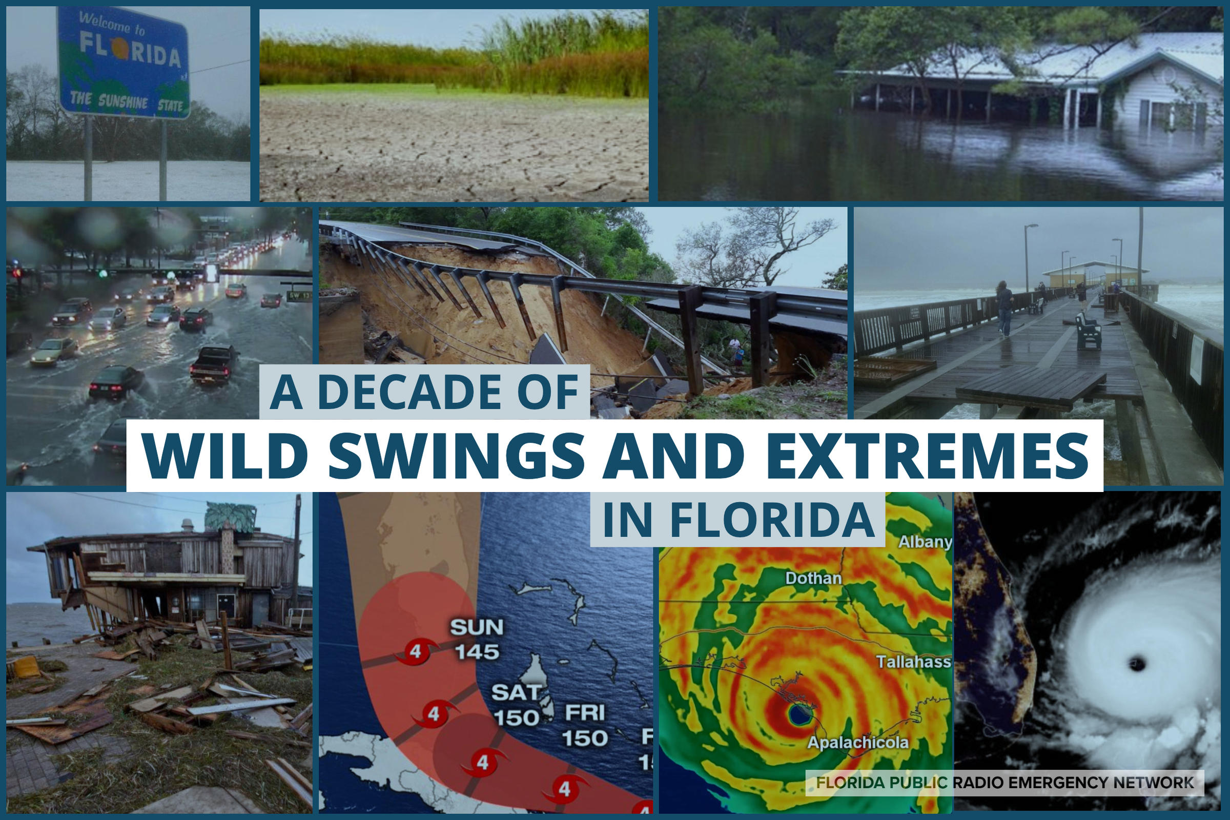
Gainesville, Florida -It’s been a decade of wild swings and weather extremes in Florida. Record-setting temperature and precipitation trends were noted during the first half of the decade, while multiple major severe and tropical weather events characterized the last five years. We summarized the major weather stories from each year in the article below.
2010: A year governed by climate signals
The second decade of the second millennium began with a strong El Nino. This warming of sea surface temperatures in the eastern Pacific often correlates to an uptick in severe weather in the Southeast. Multiple rounds of strong thunderstorms moved through Florida in January that year. The most notable event occurred on Jan. 21, 2010 when an EF-1 tore through the Bradford County town of Starke. The twister carved a 10 mile path through several neighborhoods and crossed State Highway 301. Thankfully there were no deaths or injuries reported, but extensive property damage was incurred by dozens of local residents.
Another climate pattern, and its subsequent impact on Florida, arrived in December. The Arctic Oscillation Index is used to measure anomalies in pressure at the North Pole. It entered a negative phase, which allowed arctic air to plunge deep into the eastern half of the United States for many days. According to the National Weather Service, December 2010 was the coldest December on record for both central and south Florida. The coldest morning was on Dec. 28, when frost was reported as far south as Miami.
2011: Heat-waves, drought, and fires
The El Niño that dominated the early part of 2010 gradually faded by the end of the year. El Nino’s counterpart, La Nina, began to develop in the eastern Pacific by the spring of 2011. This cooler-than-normal spell of sea surface temperatures usually translates to a warmer and drier weather period of weather in the Southeast. And this is precisely what occurred.
An extreme drought developed over much of Florida during the spring months, and this was followed by a record-setting heat wave in early summer. Wildfires were widespread for several months, and an estimated 299,991 acres of land were burned across the Sunshine State in 2011.
2012: First tropical storm of the decade
Florida had yet to be affected by a tropical storm or hurricane this decade until June of 2012. A tropical storm named Debby made landfall on the 26th near the mouth of the Suwannee River in Florida’s Big Bend. The slow-moving storm stunned residents of North Florida with 20 to 30 inches of rain, causing extensive flooding that lingered for weeks. Entire neighborhoods near Live Oak and Lake City became inhabitable, and a record flood occurred along the Sopchoppy River in Wakulla County.
Debby’s outer rain bands also spawned 10 tornadoes across the Florida peninsula, with the most notable ones touching down in Collier and Palm Beach Counties. All of the twisters were rated an EF-0, but they caused notable damage and were unfortunately responsible for one death.
2013: Wettest Summer on Record
The drought in 2011 was largely erased by Tropical Storm Debby in 2012, and the rain kept falling in 2013. It was the wettest summer on record for the state (at the time), and according to the Florida Climate Center, a statewide average of 27.87” of rain fell between June and August that year.
Tropical Storm Andrea was the largest contributor to the soggy summer. Taking a similar path as Tropical Storm Debby, Andrea made landfall in Dixie County June 6th. Rainfall accumulations exceeded five inches in portions of central Florida, and Andrea’s rain squalls spawned 10 tornadoes that ripped through the eastern half of the state from the First Coast to Palm Beach County.
2014: Double trouble in the Panhandle
2014 was not a nice year (weather speaking) along Florida’s Emerald Coast. Two extreme precipitation events with the span of three months shut down roads, closed schools, and even damaged homes near Pensacola. One was a rare ice storm, the second a freak flash flood.
A seemingly endless supply of arctic air flowed into Florida’s Panhandle during the first few weeks of January. This was followed by a winter storm on Jan. 28-29 that pelted the region with sleet and freezing rain. Ice accumulations of up to 1/2 inch closed Interstate 10 for 200 miles, and accumulating sleet even fell at the beaches.
Exactly three months later, on April 28 and 29, another extreme event hit the same areas of the western panhandle. A stalled front produced round after round of torrential rain. Two-day totals exceeded 20 inches, and in Pensacola six inches of rain fell in one hour. This produced extensive flash flooding that destroyed sections of major roads and caused numerous sinkholes.
2015: A relatively quiet year
Another flooding event hit the Florida Panhandle in 2015, but it wasn’t as extreme as what took place in 2014. The remnants of Hurricane Patricia (from the Pacific Ocean) moved along the Gulf Coast in October, dropping over seven inches of rain over the course of three days in some spots. Gusty winds and ten foot waves contributed to substantial coastal flooding, and the rough seas caused a floating restaurant near Destin to sink.
No other major weather events or significant temperature trends were noted in 2015. However, El Nino was planning a comeback that would manifest itself in the form of severe weather the following year.
2016: Tornadoes and hurricanes
28 tornadoes touched down in Florida during the months of January and February in 2016. Two of them were rated EF-3, each producing substantial damage to homes and businesses near Pensacola and Century, Florida. There were numerous injuries reported, but thankfully no fatalities.
At this point in the decade, one event was markedly missing from the history books: a hurricane. This would soon change.
Florida’s 10-year hurricane drought came to end on Sept. 1 when Hermine made landfall in Florida’s Big Bend as a Category 1 storm. Damage was extensive in and around Tallahassee, where wind gusts exceeded 60 mph and three tornadoes were confirmed by the National Weather Service. Hermine produced the fifth highest storm surge near Cedar Key and dumped more than five inches of rain up and down the Nature Coast.
Just a few weeks later, residents along the Atlantic coast were staring at a major hurricane named Matthew. Even though it didn’t officially make landfall, significant wind damage and storm surge flooding occurred from the First Coast to the Space Coast. Highest rainfall amounts were recorded in the Jacksonville Metro area, and ranged between 10 and 15 inches. The highest recorded gust in Florida was 93 mph at the Kennedy Space Center.
2017: Hurricane Irma
The 2017 Atlantic Hurricane Season was considered hyperactive, featuring 17 named storms, 10 hurricanes, and 6 major hurricanes. It was also the costliest tropical cyclone season on record in the United States. Historic flooding from Hurricane Harvey in Texas and Louisiana captured most of America’s attention in late August, but it was the next storm on the list that began to worry Floridians.
Irma was the first major hurricane to officially hit Florida since Wilma in 2005. The category 5 monster tracked across the Atlantic for nearly two weeks, before making landfalls as a Category 3 storm at Cudjoe Key and Marco Island on Sept. 10. The extremely large hurricane then tracked up the Florida peninsula, spreading destructive winds and flooding rains from coast to coast. Wind gusts up to 120 mph were reported near Naples, and tropical storm force winds destroyed trees and damaged roofs as far north as the Florida-Georgia border. 10 to 15 inches of rain fell in Irma’s path, and both coastlines were inundated with several feet of storm surge. More than 6.7 million utility customers lost power, and at least 84 deaths were directly or indirectly caused by the hurricane. Damage estimates across Florida topped $50 billion.
2018: Hurricane Michael
The impacts of Hurricane Irma seemed unsurpassable at the time, but one year later, the worst case scenario unfortunately came to pass. A category 5 hurricane, intensifying rapidly just before landfall, slammed ashore with only a few day’s notice.
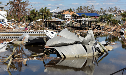
Hurricane Michael hit Mexico Beach on Oct. 10, 2018 with winds up to 160 mph. It’s ferocious eye wall damaged or destroyed tens of thousands of homes,
We have included a detailed account of the damage from Hurricane Michael from the National Hurricane Center’s official report (page 11) on the storm published on May 17, 2019.
Michael’s winds and storm surge caused devastating to catastrophic damage in Bay County, Florida, with the worst of the damage occurring in Mexico Beach (Fig. 10) and at the Tyndall AFB. In Mexico Beach, 1,584 buildings out of 1,692 in the town were reported damaged, with 809 of those reported destroyed. While exact numbers are not available from the Tyndall AFB, every building was reported damaged with many destroyed. The winds and surge also caused less severe, but extensive, damage elsewhere in the eastern portion of the Panama City metropolitan area. This resulted in a total of more than 45,000 structures damaged and more than 1,500 destroyed in Bay County, including severe damage to two hospitals.
Widespread damage also occurred along the Florida Gulf Coast east of the Panama City area to Alligator Point. In Gulf County, over 2,000 structures suffered minor damage, while more than 1,200 received major damage and 985 structures reported as destroyed. An additional 80 structures were reported destroyed in Franklin County. Coastal highways were also washed out in several places between Panama City and Alligator Point. Relatively minor damage was reported along the coast east of Alligator Point to near Keaton Beach.
Inland, a swath of major wind damage to both structures and agriculture/forestry occurred along the track of Michael from the Florida Panhandle across extreme southeastern Alabama into southwestern and central Georgia. Jackson County, Florida, including the town of Mariana, was hard hit, with 400 buildings reportedly destroyed and 600 more suffering major damage. Farther to the northeast, Seminole County, Georgia, including the town of Donaldsonville, reported damage to 99% of the homes, along with severe damage to timber and agriculture. Also hard hit was Dougherty County, Georgia, including the town of Albany, which reported 3,000 residential structures damaged (including 49 destroyed) and significant damage to timber and agriculture. Elsewhere along the path of Michael, a combination of wind and freshwater flooding caused relatively minor damage from eastern Georgia northeastward through southeastern Virginia.
As of this writing, the NOAA National Centers for Environmental Information estimates the total damage from Michael in the United States at approximately $25 billion. Of this total, about $18.4 billion occurred in Florida (with about $3 billion of this on Tyndall AFB), $4.7 billion occurred in Georgia, and $1.1 billion occurred in southeastern Alabama, with smaller amounts of damage in South Carolina, North Carolina, and Virginia. The vast majority of this damage was to property and infrastructure. However, about $3.3 billion of the damage was agricultural and forestry losses, primarily in Florida and Georgia. Widespread power outages occurred due to the storm, especially in the Florida Panhandle, extreme southeastern Alabama, and southwestern and central Georgia.
Michael was the strongest storm on record to hit the Florida panhandle. It killed 50 Floridians and produced an estimated $18.4 billion in damage across the state. Communities in the Panhandle are still struggling to rebuild their homes, businesses and livelihoods after the catastrophic hurricane. The Florida Disaster Fund helps provide financial support to Florida’s communities in times of disaster. To make a contribution, please visit www.FloridaDisasterFund.org or text DISASTER to 20222 to make a one-time donation of $10.
2019: More Scares, but Mostly Unscathed
Another massive hurricane threatened Florida in 2019, but much of the state was spared. Hurricane Dorian was a catastrophic storm when it hit the Bahamas on Sept. 1 with winds of 185 mph. The category 5 monster then stalled less than 100 miles from Miami for more than 12 hours!
With images of Hurricane Michael’s destructive winds fresh in their minds, many Floridians feared there would be a repeat of that type of damage along the Space and Treasure Coasts from Dorian. Thankfully, forecasts of a northward turn verified and the storm stayed well offshore. Moderate storm surge flooding was reported from Jupiter Inlet to Jacksonville, and there were some sporadic reports of wind damage. However, most Floridians were left untouched by Dorian’s destructive power.
Two notable tornado outbreaks also occurred in 2019. Five confirmed tornadoes touched down in the Panhandle on March 3, one of which was an EF-3 that tore through Leon County. Tropical Storm Nestor also spawned three tornadoes over west-central sections of the state in October, with the most notable one rated an EF-2 near Lakeland.
Final Thoughts
Thousands of Floridians were directly affected in a negative way by individual weather events of the past decade. Many Floridians have also witnessed firsthand how climate change has affected their community or livelihood. For example, hundreds of records high and low temperatures were recorded, and many cities likely experienced one of the warmest decades in history. This data is evaluated every 10 years by the National Weather Service, so by this time next year we should know how extreme the overall numbers were, and what could be considered a new “normal”.
The Florida Public Radio Emergency Network was founded in 2015 to be a lifeline for your community in times of need. We’re reachable from anywhere in the state on public radio, or on any device via social media and our app Florida Storms. We stand ready to serve you any time hazardous weather threatens our state, but we wish and hope for nothing but the best nature has to offer in 2020 and beyond.
Story by Meteorologist Megan Borowski & Jeff Huffman