
BULLETIN
Potential Tropical Cyclone Nine Advisory Number 1
NWS National Hurricane Center Miami FL AL092019
500 PM EDT Thu Sep 12 2019
…A TROPICAL CYCLONE IS EXPECTED TO FORM NEAR THE NORTHWESTERN
BAHAMAS…
SUMMARY OF 500 PM EDT…2100 UTC…INFORMATION
———————————————-
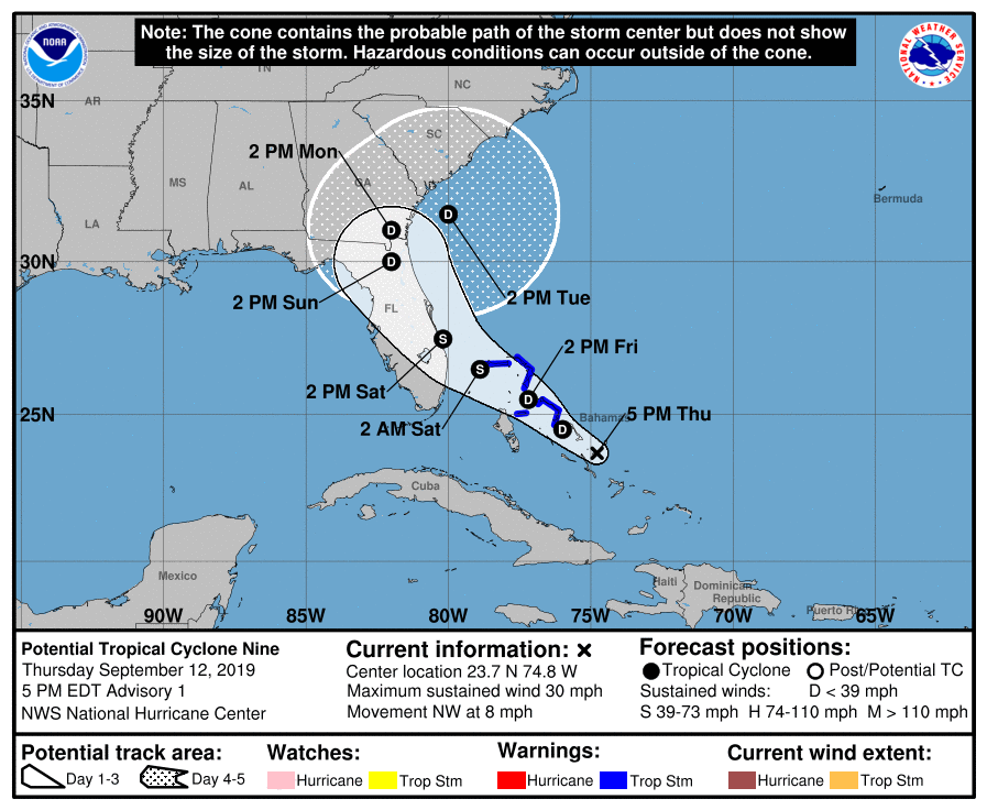
LOCATION…23.7N 74.8W
ABOUT 235 MI…380 KM SE OF GREAT ABACO ISLAND
ABOUT 310 MI…500 KM SE OF FREEPORT GRAND BAHAMA ISLAND
MAXIMUM SUSTAINED WINDS…30 MPH…45 KM/H
PRESENT MOVEMENT…NW OR 305 DEGREES AT 8 MPH…13 KM/H
MINIMUM CENTRAL PRESSURE…1008 MB…29.77 INCHES
WATCHES AND WARNINGS
——————–
CHANGES WITH THIS ADVISORY:
The government of the Bahamas has issued a Tropical Storm Warning
for the following islands in the northwestern Bahamas the Abacos,
Berry Islands, Bimini, Eleuthera, Grand Bahama Island, and New
Providence.
SUMMARY OF WATCHES AND WARNINGS IN EFFECT:
A Tropical Storm Warning is in effect for…
* Northwestern Bahamas excluding Andros Island
A Tropical Storm Warning means that tropical storm conditions are
expected somewhere within the warning area within 36 hours.
Interests along the east coast of Florida should monitor the
progress of this system.
For storm information specific to your area, please monitor
products issued by your national meteorological service.
DISCUSSION AND OUTLOOK
———————-
At 500 PM EDT (2100 UTC), the disturbance was centered near latitude
23.7 North, longitude 74.8 West. The system is expected to move
toward the northwest near 8 mph (13 km/h), and this motion is
forecast to continue during the next 2 days. On this track, the
system is anticipated to move across the northwestern Bahamas on
Friday, and along or over the east coast of central Florida on
Saturday.
Maximum sustained winds are near 30 mph (45 km/h) with higher gusts.
The disturbance is forecast to become tropical depression or a
tropical storm during the next day or so.
Environmental conditions are favorable for a tropical depression or
tropical storm to form within the next day or two.
* Formation chance through 48 hours…high…70 percent
* Formation chance through 5 days…high…80 percent
The estimated minimum central pressure is 1008 mb (29.77 inches).
HAZARDS AFFECTING LAND
———————-
WIND: Tropical storm conditions are expected within the warning
area in the northwest Bahamas by late Friday.
RAINFALL: The system is expected to produce total rain accumulations
of 2 to 4 inches through Sunday over the Bahamas and along
the east coast of Florida north of West Palm Beach. Isolated maximum
amounts of 7 inches are possible in the northwest and central
Bahamas.
STORM SURGE: This system is not expected to product significant
storm surge in the northwest Bahamas.
NEXT ADVISORY
————-
Next intermediate advisory at 800 PM EDT.
Next complete advisory at 1100 PM EDT.
$$
Forecaster Avila
Potential Tropical Cyclone Nine Discussion Number 1
NWS National Hurricane Center Miami FL AL092019
500 PM EDT Thu Sep 12 2019
The disturbance in the southeastern Bahamas has not developed a
closed circulation yet, but the cloud pattern is gradually becoming
better organized. An Air Force plane is currently approaching the
disturbance, and will give NHC more details on the structure of the
system. Advisories are being initiated on this system as a
Potential Tropical Cyclone to allow for the issuance of a tropical
storm warning for a portion of the northwest Bahamas after
consultation with the meteorological service of that country.
The system is still under the influence of strong shear caused by an
upper-level low in the Gulf of Mexico. As the disturbance moves away
from the upper low, conditions are expected to be a little more
conducive for development as indicated in the intensity forecast.
With the exception of the GFS, which forecasts a vigorous trough
crossing Florida into the Gulf of Mexico, the remainder of the
global models develop a tropical cyclone near the northwestern
Bahamas and move it as an intensifying system very close to the east
coast of Florida. The NHC forecast opted for the solution of these
latter models, however, it is emphasized that given the model
discrepancy, both the track and intensity forecasts are highly
uncertain, more than usual I would say.
Key Messages:
1. The disturbance is expected to become a tropical storm and bring
tropical storm force winds to portions of the northwest Bahamas
within 36 hours. As a result, advisories have been initiated on
Potential Tropical Cyclone Nine. Note that forecast uncertainty for
these disturbances is generally larger than for tropical cyclones,
especially beyond 48-72 hours.
2. The system is expected to bring tropical-storm-force winds and
heavy rainfall to portions of the northwest Bahamas on Friday and
Saturday. Significant storm surge is not expected in the northwest
Bahamas from this system. Residents there should follow any advice
given by local officials.
3. The system could bring tropical-storm-force winds and rainfall
to portions of the Florida east coast over the weekend. Residents
there should monitor the progress of this system.
FORECAST POSITIONS AND MAX WINDS
INIT 12/2100Z 23.7N 74.8W 25 KT 30 MPH…POTENTIAL TROP CYCLONE
12H 13/0600Z 24.5N 76.0W 25 KT 30 MPH
24H 13/1800Z 25.5N 77.2W 30 KT 35 MPH…TROPICAL CYCLONE
36H 14/0600Z 26.5N 78.9W 40 KT 45 MPH
48H 14/1800Z 27.5N 80.2W 45 KT 50 MPH
72H 15/1800Z 30.0N 82.0W 30 KT 35 MPH…INLAND
96H 16/1800Z 31.0N 82.0W 25 KT 30 MPH…INLAND
120H 17/1800Z 31.5N 80.0W 30 KT 35 MPH…OVER WATER
$$
Forecaster Avila


