
Tropical Depression Nine Advisory Number 5
NWS National Hurricane Center Miami FL AL092019
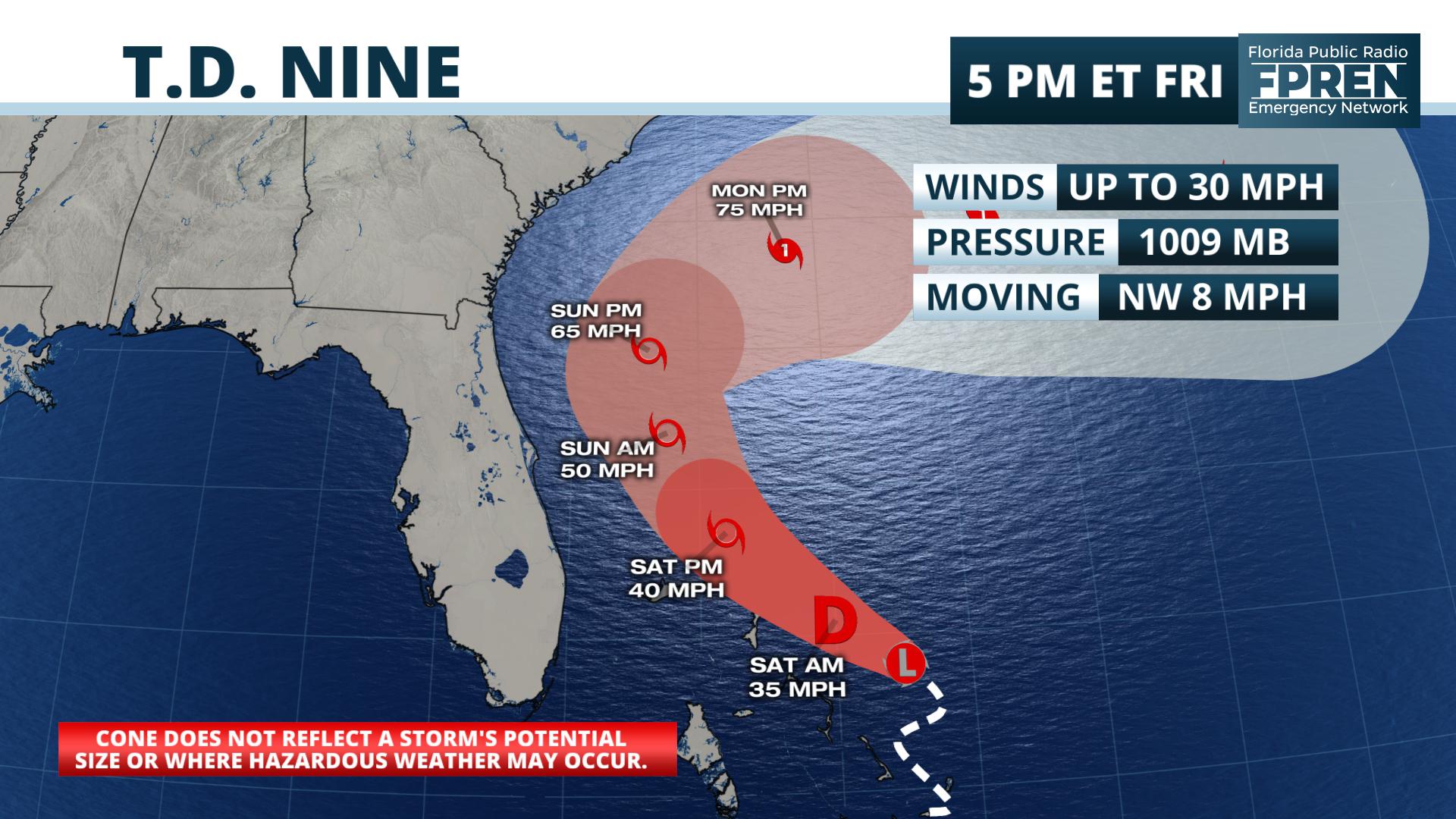
500 PM EDT Fri Sep 13 2019
…TROPICAL DEPRESSION FORMS NEAR THE BAHAMAS…
…FORECAST TO BECOME A TROPICAL STORM ON SATURDAY…
SUMMARY OF 500 PM EDT…2100 UTC…INFORMATION
———————————————-
LOCATION…25.6N 75.0W
ABOUT 240 MI…385 KM ESE OF FREEPORT GRAND BAHAMA ISLAND
ABOUT 140 MI…230 KM ESE OF GREAT ABACO ISLAND
MAXIMUM SUSTAINED WINDS…30 MPH…45 KM/H
PRESENT MOVEMENT…NW OR 305 DEGREES AT 8 MPH…13 KM/H
MINIMUM CENTRAL PRESSURE…1009 MB…29.80 INCHES
WATCHES AND WARNINGS
——————–
CHANGES WITH THIS ADVISORY:
None.
SUMMARY OF WATCHES AND WARNINGS IN EFFECT:
A Tropical Storm Warning is in effect for…
* Northwestern Bahamas excluding Andros Island
A Tropical Storm Watch is in effect for…
* Jupiter Inlet to Flagler-Volusia County line
A Tropical Storm Warning means that tropical storm conditions are
expected somewhere within the warning area within 36 hours.
A Tropical Storm Watch means that tropical storm conditions are
possible within the watch area, generally within 48 hours.
Interests elsewhere along the east coast of Florida should monitor
the progress of this system. Additional watches and warnings may
be required for portions of this area later today.
For storm information specific to your area in the United States,
including possible inland watches and warnings, please monitor
products issued by your local National Weather Service forecast
office. For storm information specific to your area outside of the
United States, please monitor products issued by your national
meteorological service.
DISCUSSION AND OUTLOOK
———————-
At 500 PM EDT (2100 UTC), the center of Tropical Depression Nine was
located near latitude 25.6 North, longitude 75.0 West. The
depression is moving toward the northwest near 8 mph (13 km/h). A
turn toward the north-northwest is expected on Saturday. On
the forecast track, the system is anticipated to move very near the
northwestern Bahamas tonight and Saturday, and east of the east
coast of Florida during Saturday and Sunday.
Maximum sustained winds are near 30 mph (45 km/h) with higher gusts.
Some strengthening is forecast during the next 48 hours. The
depression is forecast to become a tropical storm on Saturday.
The estimated minimum central pressure is 1009 mb (29.80 inches).
HAZARDS AFFECTING LAND
———————-
WIND: Tropical storm conditions are expected within the warning
area in the northwestern Bahamas tonight and early Saturday.
Tropical storm conditions are still possible in the watch area on
the Florida peninsula by Saturday or Saturday night.
RAINFALL: The potential tropical cyclone is expected to produce
total rainfall accumulations through Sunday:
The Bahamas…2 to 4 inches, isolated maximum amounts 6 inches.
The U.S. Atlantic Coast from central Florida into South
Carolina…2 to 4 inches.
STORM SURGE: This system is not expected to product significant
storm surge in the northwestern Bahamas.
NEXT ADVISORY
————-
Next intermediate advisory at 800 PM EDT.
Next complete advisory at 1100 PM EDT.
$$
Forecaster Avila
Tropical Depression Nine Discussion Number 5
NWS National Hurricane Center Miami FL AL092019
500 PM EDT Fri Sep 13 2019
An Air Force plane extensively investigated the disturbance near the
Bahamas during the past several hours, and in the last portion of
the mission, the crew was able to locate a center of circulation,
although weak, near the convection. The center was a little bit
to the east of the previous estimates. Satellite images also
indicate that the cloud pattern has become a little better organized
and Dvorak estimates are T2.0 and 1.5 from TAFB and SAB,
respectively. On this basis, the disturbance has been classified as
a tropical depression with 25 kt winds.
Conditions are not ideal for strengthening since the depression
is still embedded within a moderate shear environment, but
this parameter is not expected to be strong enough to halt
additional development. The NHC forecast still calls for this system
to become a tropical storm on Saturday with gradual intensification
thereafter. Global models insist on further development, and the
reliable guidance suggests that the cyclone could even reach
hurricane intensity in about 3 days, and so does the NHC forecast.
By then, the system is expected to be over the Atlantic waters well
southeast of the coast of the Carolinas.
Due to the reformation of the apparent center, the initial motion is
highly uncertain. The best estimate is toward the northwest or 305
degrees at 7 kt. A weakness in the ridge over the western Atlantic
is forecast to develop, and this pattern should steer the system
slowly toward the northwest and then northward. In about 3 days, an
eastward moving mid-latitude trough will force the system to recurve
away from the coast toward the Atlantic. The track guidance has
shifted to the east again, and this shift is larger due to the
eastward formation of the center. Consequently, the NHC track
forecast was adjusted in that direction, but it remains on the
western edge of the guidance envelope.
Key Messages:
1. The depression is forecast to become a tropical storm within
the next 24 hours and will likely bring tropical-storm-force winds
and heavy rainfall to portions of the northwestern Bahamas later
today and Saturday. Significant storm surge is not expected in the
northwest Bahamas from this system. Residents there should follow
any advice given by local officials.
2. The system could still bring tropical storm conditions to
portions of the Florida east coast. Residents there should monitor
the progress of this system and follow any advice given by local
officials.
3. Heavy rainfall and scattered flash flooding is possible this
weekend in coastal sections of eastern Florida, Georgia, and South
Carolina. The chance of heavy rainfall affecting coastal North
Carolina early next week continues to diminish.
FORECAST POSITIONS AND MAX WINDS
INIT 13/2100Z 25.6N 75.0W 25 KT 30 MPH
12H 14/0600Z 26.2N 76.0W 30 KT 35 MPH
24H 14/1800Z 27.4N 77.6W 35 KT 40 MPH
36H 15/0600Z 28.8N 78.5W 45 KT 50 MPH
48H 15/1800Z 30.0N 78.8W 55 KT 65 MPH
72H 16/1800Z 31.5N 76.5W 65 KT 75 MPH
96H 17/1800Z 32.0N 73.0W 70 KT 80 MPH
120H 18/1800Z 32.5N 68.0W 75 KT 85 MPH
$$
Forecaster Avila


