
Subtropical Storm Andrea Special Advisory Number 1
NWS National Hurricane Center Miami FL AL012019
630 PM AST Mon May 20 2019
…SUBTROPICAL STORM ANDREA FORMS OVER THE WESTERN ATLANTIC…
SUMMARY OF 630 PM AST…2230 UTC…INFORMATION
———————————————-
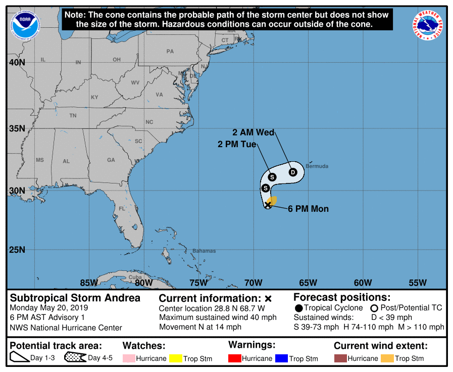
LOCATION…28.8N 68.7W
ABOUT 335 MI…540 KM SW OF BERMUDA
MAXIMUM SUSTAINED WINDS…40 MPH…65 KM/H
PRESENT MOVEMENT…N OR 350 DEGREES AT 14 MPH…22 KM/H
MINIMUM CENTRAL PRESSURE…1006 MB…29.71 INCHES
WATCHES AND WARNINGS
——————–
There are no coastal watches or warnings in effect. Interests in
Bermuda should monitor the progress of this system.
DISCUSSION AND OUTLOOK
———————-
At 630 PM AST (2230 UTC), the center of Subtropical Storm Andrea was
located near latitude 28.8 North, longitude 68.7 West. The storm is
moving toward the north near 14 mph (22 km/h). A decrease in
forward speed and a turn to the northeast is expected on Tuesday,
followed by an eastward motion by Tuesday night. On the forecast
track, the center of Andrea is expected to remain southwest or
south of Bermuda during the next day or two.
Data from an Air Force Reserve Hurricane Hunter plane indicate that
the maximum sustained winds are near 40 mph (65 km/h) with higher
gusts. Slight strengthening is possible overnight. Weakening should
begin late Tuesday, and Andrea is expected to dissipate on
Wednesday.
Winds of 40 mph extend outward up to 70 miles (110 km) northeast of
the center.
The Air Force Hurricane Hunters measured a minimum central pressure
of 1006 mb (29.71 inches).
HAZARDS AFFECTING LAND
———————-
None
NEXT ADVISORY
————-
Next complete advisory at 1100 PM AST.
$$
Forecaster Cangialosi
Subtropical Storm Andrea Special Discussion Number 1
NWS National Hurricane Center Miami FL AL012019
630 PM AST Mon May 20 2019
Satellite and aircraft data indicate that the area of low pressure
that the National Hurricane Center has been monitoring to the
southwest of Bermuda has developed into a subtropical storm.
The Air Force Hurricane Hunters have recently exited the cyclone and
found that the system has developed a well-defined center and has a
minimum pressure of about 1006 mb. The maximum adjusted flight-level
and surface SFMR winds support an intensity of about 35 kt. The
cyclone is considered subtropical at this time because it is
interacting with an upper-level low pressure system to its west,
has a relatively large radius of maximum wind, and its overall
appearance in satellite images.
Based on satellite and aircraft fixes today, the initial motion of
Andrea is estimated to be northward at 12 kt as it has been moving
in the flow between a subtropical ridge to its east and a mid- to
upper-level low to its west. The models show Andrea slowing down
and gradually turning to the northeast on Tuesday and eastward by
Tuesday night as it moves on the northern periphery of the ridge.
Andrea could strengthen slightly through early Tuesday while it
remains in a fairly moist and unstable atmosphere. However, after
that time, gradual weakening should commence due to less favorable
conditions, and all of the reliable models show Andrea opening into
a trough and becoming absorbed by a cold front on Wednesday. The
NHC official track forecast lies near the middle of the guidance
envelope.
FORECAST POSITIONS AND MAX WINDS
INIT 20/2230Z 28.8N 68.7W 35 KT 40 MPH
12H 21/0600Z 30.2N 68.9W 40 KT 45 MPH
24H 21/1800Z 31.1N 68.3W 35 KT 40 MPH
36H 22/0600Z 31.5N 66.4W 30 KT 35 MPH
48H 22/1800Z…DISSIPATED
$$
Forecaster Cangialosi

