
Gainesville, Florida – The first tropical storm of the year may be forming in the Atlantic, even though the Atlantic Hurricane Season doesn’t officially start until June 1.
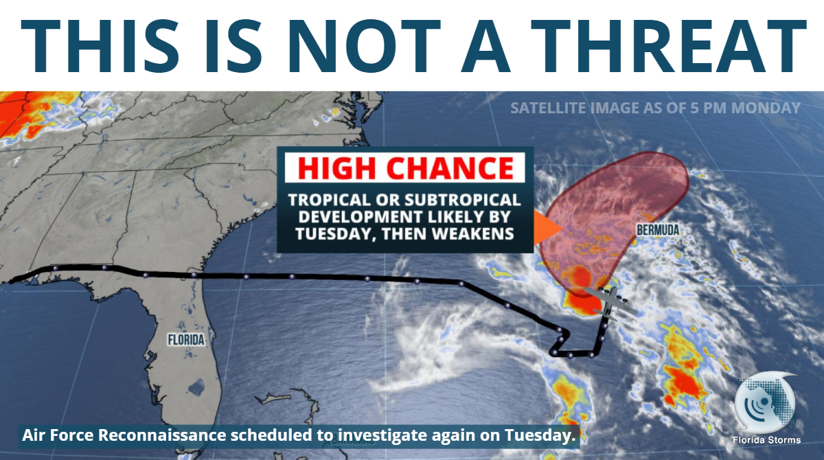
National Hurricane Center forecasters said, according to a special statement issued Monday afternoon, that there is a 70 percent chance a tropical or subtropical system will form a few hundred miles southwest of Bermuda in the next 48 hours. A Hurricane Hunter Aircraft flew into the area of disturbed weather, referred to by Meteorologists as “Invest 90”, Monday afternoon. A second flight is also scheduled Tuesday, if necessary.
Data from the first couple of passes by the plane did not conclusively determine whether a low-level center of circulation had been established, nor did it find winds high enough to classify Invest 90 as a tropical depression. If sustained winds of 39 mph or greater are discovered, the tropical or subtropical storm will be named “Andrea”.
Heavy rain and gusty winds from the system may affect Bermuda Tuesday and Wednesday, regardless of whether it becomes a named tropical storm or not. The system is likely to interact with an approaching front and encounter a hostile environment Wednesday, making additional strengthening unlikely later this week.
Statistically, a tropical storm only forms between December 31 and May 31 (during the “off season”) in the Atlantic Basin once every five years, but ironically there has been one each of the past four years. According to data from the National Hurricane Center’s web site, the average date of the first named tropical cyclone is July 9.
Special Tropical Weather Outlook
ZCZC MIATWOAT ALL
TTAA00 KNHC DDHHMM
Special Tropical Weather Outlook
NWS National Hurricane Center Miami FL
130 PM EDT Mon May 20 2019
For the North Atlantic…Caribbean Sea and the Gulf of Mexico:
1. Showers and thunderstorms associated with a broad area of low
pressure located several hundred miles southwest of Bermuda are
showing signs of organization. Although recent satellite wind data
suggest that the system currently lacks a well-defined center of
circulation, environmental conditions are expected to be conducive
for the formation of a short-lived subtropical or tropical cyclone
later today or tonight. Conditions are forecast to become
unfavorable for further development by late Tuesday, and the
disturbance is expected to merge with a cold front on Wednesday.
An Air Force Reserve reconnaissance aircraft is currently en route
to investigate the disturbance. Interests in Bermuda should
monitor the progress of this system. The next Special Tropical
Weather Outlook will be issued by 8 PM EDT today.
* Formation chance through 48 hours…high…70 percent.
* Formation chance through 5 days…high…70 percent.
Forecaster Brown
Meteorologist Ray Hawthorne of FPREN co-authored this story. WKGC is a FPREN radio station in NW Florida.
This post will expire at 12:00 pm on Tuesday May 21st, 2019
