

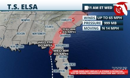
FPREN HQ – A Hurricane Warning was issued from Steinhatchee River to Egmont Key, as Tropical Storm Elsa is now expected to become a hurricane prior to landfall along the Nature Coast early Wednesday.
As of 2 pm Tuesday, Tropical Storm Elsa was found to have maximum winds of 70 mph, which was based on Air Force Reserve hurricane hunter aircraft observations and nearby radar data. While conditions are not conducive for significant strengthening, the National Hurricane Center upgraded the watch to a warning in a special advisory Tuesday afternoon, stating that “only a slight increase in intensity” would result in Elsa becoming a hurricane.
There were no significant changes to the forecast track or overall impacts expected from Tropical Storm Elsa with the special advisory. As expected, the storm has begun to move north, where a path parallel to the west coast of Florida will continue Tuesday evening, followed by an eventual landfall along the Nature Coast early Wednesday.
A Storm Surge Warning continues from Bonita Beach northward to the Apalachee Bay, where a life-threatening storm surge is possible from the persistent onshore winds on Elsa’s eastern side. Swift water flooding of 3 to 5 feet above dry ground is possible from Aucilla River to Englewood, including all of the Nature Coast and Tampa Bay. A 2 to 4 foot storm surge is expected for areas farther south to Bonita Beach, with 1 to 3 feet of flooding possible south of there into the Florida Bay and Florida Keys.
A Tropical Storm Warning continues for all Gulf Coast counties in Florida from Flamingo northward to the Ocholockonee River, and from Craig Key westward to Key West. The warning has also been expanded eastward to include inland areas of North Florida from Lake City to Gainesville to Ocala. Trropical storm force winds in the 40 to 60 mph range are likely in the warned areas as the heaviest rain bands from Elsa rotate through. Wind gusts up to 50 mph are possible farther inland across sections of north and central Florida, also colocated with the heaver rain bands, where the watches are in effect.
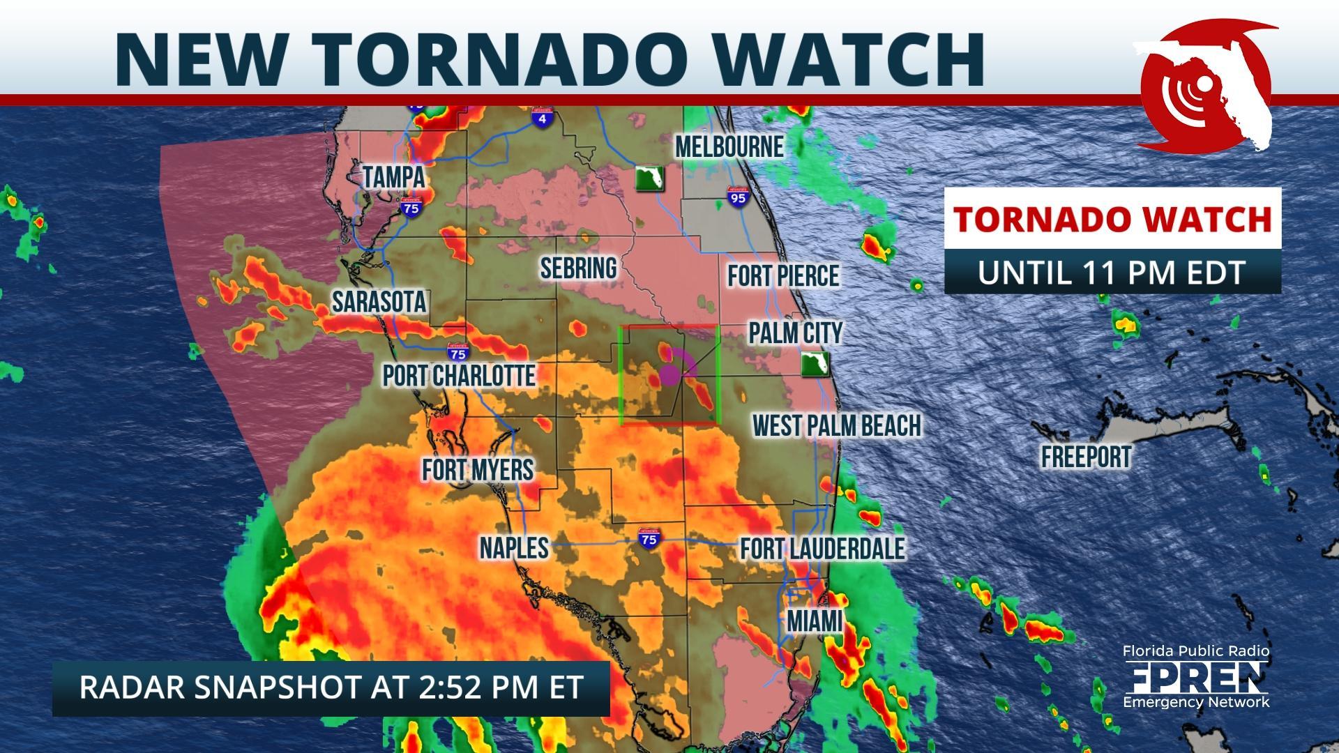
A few tornadoes may occur from Tropical Storm Elsa’s circulation as far east as the Atlantic Coast Tuesday afternoon . Some of the outer rain bands and squalls may acquire rotation as they pinwheel farther away from the storm’s center and encounter a more unstable environment from less cloud cover and warmer afternoon temperatures. Areas most at risk for this to occur are roughly near and east of the I-75 corridor in North Florida and along and east of the Florida Turnpike in Central Florida. Waterspouts and brief tornadoes may also occur from the outer rain bands closer to Elsa’s center along Florida’s west coast too.
Flash flooding is possible from Tropical Storm Elsa, although the steady forward motion of the storm should prevent it from becoming a widespread hazard. Rainfall amounts of 2 to 4 inches are expected across the western half of the Florida peninsula, with isolated amounts up to 6 inches possible. 1 to 3 inches of rain are possible across the eastern side of the state and in eastern portions of the Florida Panhandle from Elsa.
Tropical Storm Elsa is forecast to weaken after the storm moves inland across North Florida Wednesday morning, likely being downgraded to a Tropical Depression as it crosses the border into southeast Georgia Wednesday afternoon. However, enhancements to the typical afternoon downpours may continue well into Wednesday and Thursday across the Florida peninsula thanks to a deep flow of moisture on the southern and eastern side of the tropical storm
Story by Meteorologist Jeff Huffman of FPREN.
