
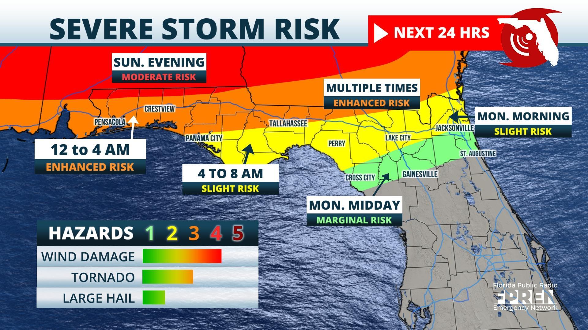
FPREN HQ – Wind damage, hail, and even a tornado are possible across sections of the Florida Panhandle late Sunday night and early Monday morning. Areas at greatest risk include the western half of the Florida Panhandle and locations farther east near and north of Interstate 10 to Jacksonville.
The Storm Prediction Center has increased the severe threat to a Moderate Risk (level 4 out of 5) for locations near the Florida and Alabama state line. An Enhanced Risk (Level 3 out of 5) is in place from Pensacola eastward to Tallahassee. The Lake City and Jacksonville areas are under at risk levels 1 and 2.
Thunderstorms began to fire Sunday afternoon along and just south of a warm front that was observed to be stretched across southern Alabama and Georgia. This boundary separates slightly cooler and drier air to the north from an increasingly warm and humid air mass to the south. As of late Sunday afternoon, only a few widely scattered thunderstorms had formed along it, and those were expected to move north of Florida by early evening.
Storm chances are highest ahead of an approaching cold front, also tied to the same storm system, when it arrives after midnight Sunday night. The severe thunderstorm risk is greatest during the following windows of time…
Pensacola – 12 to 3 am CT
Panama City – 2 to 5 am CT
Tallahassee – 4 to 8 am ET
Lake City – 7 to 11 am ET
Jacksonville – 9 am to 2 pm ET
Wind damage and large hail will be the most common hazards from the strongest storms, with the possibility of an isolated tornado. Extreme northern parts of Florida, locations closest to the Georgia and Alabama state line, are more at risk of a tornado, as the greatest atmospheric instability is expected to stay confined mostly to the southern halves of Mississippi, Alabama and Georgia.
While the severe threat is lower for North Central Florida, there is still the chance of a few strong thunderstorms forming mostly during the late morning and early afternoon hours Monday near the cities of High Springs, Lake City, Live Oak, and Gainesville. Showers and thunderstorms will also move toward the First Coast by early afternoon, before sweeping offshore by early evening. Drier conditions will arrive Tuesday as a higher pressure settles into the area.
Updates will be available on all of the severe thunderstorm threats this weekend on the Florida Storms app or social media accounts, and on your local public radio station through the Florida Public Radio Information Network.
Story by FPREN Meteorologist Jeff Huffman
