
Hurricane Dorian Tropical Cyclone Update
NWS National Hurricane Center Miami FL AL052019
930 AM EDT Sun Sep 01 2019
…CATASTROPHIC CATEGORY 5 DORIAN CONTINUING TO INTENSIFY AS IT
APPROACHES THE ABACO ISLANDS…
Data from an Air Force Reserve Hurricane Hunter aircraft indicate
that Dorian has continued to intensify, and now has maximum
sustained winds near 175 mph (280 km/h), with a minimum central
pressure of 922 mb (27.23 inches).
The eyewall of catastrophic Hurricane Dorian is currently reaching
the Abaco Islands. This is a life-threatening situation. Residents
there should take immediate shelter. Do not venture into the eye if
it passes over your location.
Hazards:
– Wind Gusts over 200 mph
– Storm Surge 15 to 20 feet above normal tide levels with higher
destructive waves
These hazards will cause extreme destruction in the affected areas.
and will continue for several hours.
SUMMARY OF 930 AM EDT…1330 UTC…INFORMATION
———————————————-
LOCATION…26.5N 76.6W
ABOUT 25 MI…40 KM ENE OF GREAT ABACO ISLAND
ABOUT 210 MI…340 KM E OF WEST PALM BEACH FLORIDA
MAXIMUM SUSTAINED WINDS…175 MPH…280 KM/H
PRESENT MOVEMENT…W OR 275 DEGREES AT 8 MPH…13 KM/H
MINIMUM CENTRAL PRESSURE…922 MB…27.73 INCHES
$$
Forecaster Brennan/Blake/Zelinsky/Avila
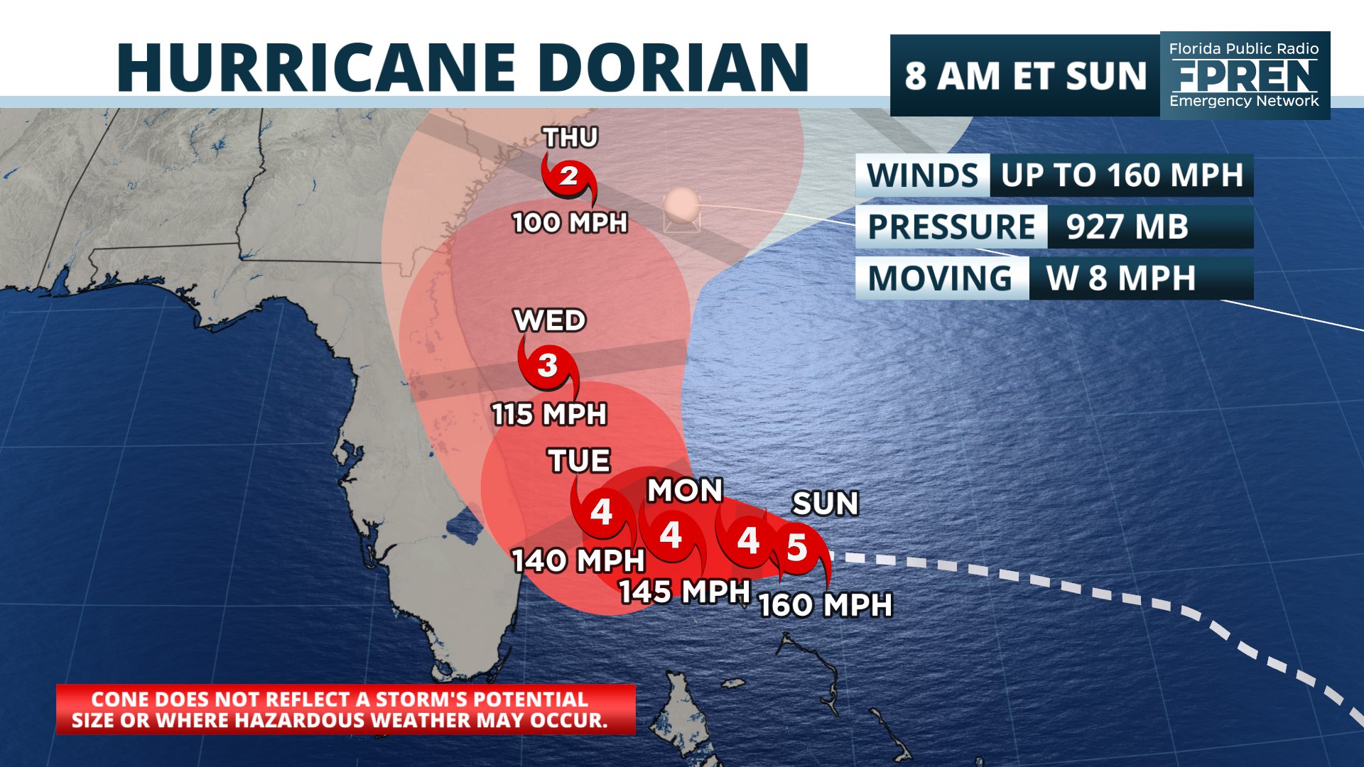
FPREN HQ – Sunday Am Update – Hurricane Dorian has become a “catestrophic” category 5 hurricane, according to the latest advisory from the National Hurricane Center.
The National Hurricane Center has made a slight westward adjustment in their forecast track for Major Hurricane Dorian overnight. This necessitated the issuance of a Tropical Storm Warning for residents along Florida’s Treasure Coast from Deerfield Beach to Sebastian Inlet.
The last line of Senior Hurricane Specialist Richard Pasch’s forecast notes Sunday morning was noteworthy for Floridian’s along the Atlantic Coast.
“Although the official track forecast does not show landfall, users should not focus on the exact track since a Florida landfall is still a distinct possibility.”
Major Hurricane Dorian is now expected to slow down before it turns to the northwest on Tuesday. Forecast Pasch went on to say in his key messages that life-threatening storm surge and dangerous hurricane-force winds are “still possible” along portions of Florida’s east coast by the middle part of the week.
The latest forecast track and official advisory information from the National Hurricane Center is available in the Florida Storms mobile app, which we also summarized in a tweet early Sunday.
Several updates overnight on Major Hurricane #Dorian...
— Florida Storms (@FloridaStorms) September 1, 2019
Left: Storm could stall Monday just E of West Palm, before turning north.
Middle: NHC says FL landfall “distinct possibility” based on avg forecast error and uncertainty factors. #FLwx
Right: TS Warning #TreasureCoast pic.twitter.com/4et4X39dHt
A significant change in the weather pattern that is steering Dorian is still likely to keep the worst of the hurricane just offshore the Florida east coast. However, the hurricane is large enough, strong enough, and could move close enough to spread tropical storm force winds across sections of the Treasure Coast.
Tropical storm force winds extend about 105 miles from the center, and forecasters say that could expand. For these reasons, Tropical Storm Watches have been issued from Deerfield Beach in Broward county to Sebastien Inlet near the Brevard/Indian River county line. High surf and rip currents are expected this weekend into early next week.
A ridge of high pressure that is steering the Dorian is forecast to keep pushing it westward this weekend toward the northwestern Bahamas. The ridge; however, is now forecast to be much weaker by Monday, which will cause it to slow or stall just offshore of Florida Monday. A turn toward the north is likely Tuesday and Wednesday, in the general direction of the Carolinas.
Tropical storm force winds could also reach parts of South Florida and the Space Coast on Monday, gradually spreading toward Daytona Beach and the First Coast on Tuesday. Hurricane force winds are becoming less likely and should stay offshore.
Coastal flooding is likely, regardless of how close Dorian gets to the state. The new moon is causing high astronomical tides during the times of high tide. The National Weather Service in Jacksonville has issued Coastal Flood Advisories. Tidal departures may reach 1 to 2 feet above normal this weekend.
NOAA’s Weather Prediction Center says 2 to 5 inches of rain may still fall along portions of the east coast, but these amounts may change depending on exactly how close the storm gets.
Story by FPREN Meteorologist Jeff Huffman