
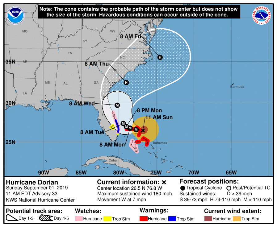
Hurricane Dorian Advisory Number 33
NWS National Hurricane Center Miami FL AL052019
1100 AM EDT Sun Sep 01 2019
…DORIAN BECOMES THE STRONGEST HURRICANE IN MODERN RECORDS FOR
THE NORTHWESTERN BAHAMAS.
…CATASTROPHIC CONDITIONS OCCURING IN THE ABACOS ISLANDS…
SUMMARY OF 1100 AM EDT…1500 UTC…INFORMATION
———————————————–
LOCATION…26.5N 76.8W
ABOUT 20 MI…30 KM ENE OF GREAT ABACO ISLAND
ABOUT 205 MI…330 KM E OF WEST PALM BEACH FLORIDA
MAXIMUM SUSTAINED WINDS…180 MPH…285 KM/H
PRESENT MOVEMENT…W OR 270 DEGREES AT 7 MPH…11 KM/H
MINIMUM CENTRAL PRESSURE…913 MB…26.96 INCHES
WATCHES AND WARNINGS
——————–
CHANGES WITH THIS ADVISORY:
A Hurricane Watch has been issued for the east coast of Florida from
north of Deerfield Beach to the Volusia/Brevard County Line.
A Storm Surge Watch has also been issued from north of Deerfield
Beach to the Volusia/Brevard County Line.
A Tropical Storm Watch has been issued for Lake Okeechobee.
SUMMARY OF WATCHES AND WARNINGS IN EFFECT:
A Storm Surge Watch is in effect for…
* North of Deerfield Beach to the Volusia/Brevard County Line
A Hurricane Warning is in effect for…
* Northwestern Bahamas excluding Andros Island
A Hurricane Watch is in effect for…
* Andros Island
* North of Deerfield Beach to the Volusia/Brevard County Line
A Tropical Storm Warning is in effect for…
* North of Deerfield Beach to Sebastian Inlet
A Tropical Storm Watch is in effect for…
* North of Golden Beach to Deerfield Beach
* Lake Okeechobee
A Storm Surge Watch means there is a possibility of life-
threatening inundation, from rising water moving inland from the
coastline, in the indicated locations during the next 48 hours.
For a depiction of areas at risk, please see the National Weather
Service Storm Surge Watch/Warning Graphic, available at
hurricanes.gov.
A Hurricane Warning means that hurricane conditions are expected
somewhere within the warning area. Preparations to protect life and
property should be rushed to completion.
A Hurricane Watch means that hurricane conditions are possible
within the watch area. A watch is typically issued 48 hours
before the anticipated first occurrence of tropical-storm-force
winds, conditions that make outside preparations difficult or
dangerous.
A Tropical Storm Warning means that tropical storm conditions are
expected within the warning area within 36 hours.
A Tropical Storm Watch means that tropical storm conditions are
possible within the watch area, generally within 48 hours.
Interests elsewhere along the east coast of Florida should continue
to monitor the progress of Dorian, as additional watches or
warnings may be required later today.
For storm information specific to your area in the United
States, including possible inland watches and warnings, please
monitor products issued by your local National Weather Service
forecast office. For storm information specific to your area
outside of the United States, please monitor products issued by
your national meteorological service.
DISCUSSION AND OUTLOOK
———————-
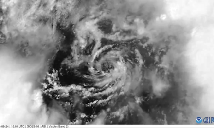
At 1100 AM EDT (1500 UTC), the extremely distinct eye of Hurricane
Dorian was located near latitude 26.5 North, longitude 76.8 West.
Dorian is moving toward the west near 7 mph (11 km/h). A slower
westward motion should continue for the next day or two, followed by
a gradual turn toward the northwest. On this track, the core of
extremely dangerous Hurricane Dorian will continue to move over
Great Abaco and move near or over Grand Bahama Island later tonight
and Monday. The hurricane should move closer to the Florida east
coast late Monday through Tuesday night.
Maximum sustained winds have increased to near 180 mph (285 km/h)
with higher gusts. Dorian is a extremely dangerous category 5
hurricane on the Saffir-Simpson Hurricane Wind Scale. Some
fluctuations in intensity are likely, but Dorian is expected to
remain a powerful hurricane during the next few days.
Dorian has grown larger in size. Hurricane-force winds extend
outward up to 45 miles (75 km) from the center and tropical-storm-
force winds extend outward up to 140 miles (220 km). Ham radio
reports indicate that Hope Town in the Abacos just reported wind
gust to 100 mph.
The minimum central pressure measured by both NOAA and Air Force
reconnaissance plane was 913 mb (26.96 inches).
HAZARDS AFFECTING LAND
———————-
WIND: Catastrophic hurricane conditions are occurring in the Abacos
Islands and will spread across Grand Bahama Island later today and
tonight.
Hurricane conditions are possible within the hurricane watch area in
Florida by late Monday or early Tuesday.
Tropical storm conditions are expected within the tropical storm
warning area on Monday and Tuesday.
Tropical storm conditions are possible within the tropical storm
watch area by Monday night.
STORM SURGE: A life-threatening storm surge will raise water levels
by as much as 18 to 23 feet above normal tide levels in areas of
onshore winds on the Abaco Islands and Grand Bahama Island. Near
the coast, the surge will be accompanied by large and destructive
waves.
The combination of a dangerous storm surge and the tide will cause
normally dry areas near the coast to be flooded by rising waters
moving inland from the shoreline. The water could reach the
following heights above ground somewhere in the indicated
areas if the peak surge occurs at the time of high tide…
Volusia/Brevard County Line to Jupiter Inlet FL…4 to 7 ft
North of Deerfield Beach to Jupiter Inlet FL…2 to 4 ft
The surge will be accompanied by large and destructive waves.
Surge-related flooding depends on the how close the center of
Dorian comes to the Florida east coast, and can vary greatly over
short distances. For information specific to your area, please see
products issued by your local National Weather Service forecast
office.
RAINFALL: Dorian is expected to produce the following rainfall
totals through late this week:
Northwestern Bahamas…12 to 24 inches, isolated 30 inches.
Coastal Carolinas…5 to 10 inches, isolated 15 inches.
Central Bahamas and the Atlantic Coast from the Florida peninsula
through Georgia…2 to 4 inches, isolated 6 inches.
This rainfall may cause life-threatening flash floods.
SURF: Large swells are already affecting east-facing shores of the
Bahamas, the Florida east coast, and will spread northward along the
southeastern United States coast during the next few days. These
swells are likely to cause life-threatening surf and rip current
conditions. Please consult products from your local weather office.
NEXT ADVISORY
————-
Next intermediate advisory at 200 PM EDT.
Next complete advisory at 500 PM EDT.
$$
Forecaster Avila
Hurricane Dorian Discussion Number 33
NWS National Hurricane Center Miami FL AL052019
1100 AM EDT Sun Sep 01 2019
Air Force and NOAA reconnaissance planes penetrated the distinct
eye of Dorian, and found that the hurricane has become extremely
intense with a stadium effect in the eye. The NOAA plane reported a
peak flight-level wind of 159 kt, while the SFMR from both planes
have measured winds between 155 and 170 kt. A dropsonde from the
NOAA plane measured a wind gust of 176 kt at the surface. A blend of
these measurements yield to an initial intensity of 155 kt, making
Dorian the strongest hurricane on record in the northwestern
Bahamas.
For the next few days, Dorian should experience some fluctuations in
intensity, and in addition to eyewall replacement cyclone, the
interaction with the northwestern Bahamas should weaken the
hurricane slightly. After 3 days, as Dorian moves northward along
or offshore of southeast United States coast, the shear is forecast
to increase, resulting in a more distinct gradual weakening.
Reconnaissance plane and satellite fixes indicate that Dorian, as
anticipated, has slowed down and is moving toward the west or 270
degrees at 6 kt. The steering currents are collapsing and Dorian is
expected to slow down even more, prolonging its catastrophic effects
in the northwestern Bahamas. The NHC forecast calls for a slow west
to west-northwest motion during the next 48 hours, with a turn to
the north and an increase in forward speed as the mid-level trough
along the eastern United States deepens and becomes the dominant
steering feature. The current forecast is only a few miles west of
the previous one and is basically on top of the multi-model
consensus. Both the deterministic and consensus tracks have shown
the usual variability to the right or to the left from run to run,
but the overall trend is for the hurricane to turn northward
offshore but very close to the Florida peninsula.
Given the uncertainty in the track forecast and the anticipated
increase in size of the hurricane, a Hurricane Watch and Storm
Surge Watch have been issued for a portion of the east Florida
coast. It is emphasized that although the official track forecast
does not show landfall, users should not focus on the exact track. A
small deviation to the left of the track could bring the intense
core of the hurricane its dangerous winds closer to or onto the
coast.
Key Messages:
1. A prolonged period of catastrophic winds and storm surge will
affect the Abaco Islands today. Everyone there should take immediate
shelter and not venture into the eye. These catastrophic conditions
are likely on Grand Bahama Island later today or tonight, and
efforts to protect life and property there should be rushed to
completion.
2. Storm surge and hurricane watches and tropical storm warnings are
in effect for portions of the Florida east coast. Life-threatening
storm surge and dangerous hurricane-force winds are possible along
portions of the Florida east coast through mid-week, as only a
slight deviation to the left of the official forecast would bring
the core of Dorian near or over the coast. Residents should listen
to advice given by local emergency officials.
3. There is an increasing likelihood of strong winds and dangerous
storm surge along the coasts of Georgia, South Carolina, and North
Carolina later this week. Residents in these areas should continue
to monitor the progress of Dorian.
4. Heavy rains, capable of producing life-threatening flash floods,
are possible over northern portions of the Bahamas and coastal
sections of the southeast and lower mid-Atlantic regions of the
United States through late this week.
FORECAST POSITIONS AND MAX WINDS
INIT 01/1500Z 26.5N 76.8W 155 KT 180 MPH
12H 02/0000Z 26.6N 77.7W 150 KT 175 MPH
24H 02/1200Z 26.8N 78.5W 145 KT 165 MPH
36H 03/0000Z 27.0N 79.0W 135 KT 155 MPH
48H 03/1200Z 27.4N 79.4W 120 KT 140 MPH
72H 04/1200Z 29.7N 80.2W 100 KT 115 MPH
96H 05/1200Z 32.5N 79.0W 85 KT 100 MPH
120H 06/1200Z 35.5N 74.5W 80 KT 90 MPH
$$
Forecaster Avila

