
Hurricane Dorian Advisory Number 25
NWS National Hurricane Center Miami FL AL052019
1100 AM AST Fri Aug 30 2019
…DANGEROUS HURRICANE DORIAN POSES A SIGNIFICANT THREAT TO
FLORIDA AND THE NORTHWESTERN BAHAMAS…
SUMMARY OF 1100 AM AST…1500 UTC…INFORMATION
———————————————–
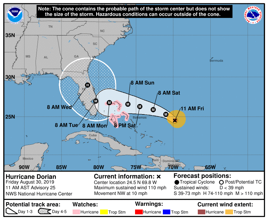
LOCATION…24.5N 69.8W
ABOUT 480 MI…770 KM E OF THE NORTHWESTERN BAHAMAS
ABOUT 660 MI…1060 KM E OF WEST PALM BEACH FLORIDA
MAXIMUM SUSTAINED WINDS…110 MPH…175 KM/H
PRESENT MOVEMENT…NW OR 310 DEGREES AT 10 MPH…17 KM/H
MINIMUM CENTRAL PRESSURE…972 MB…28.71 INCHES
WATCHES AND WARNINGS
——————–
CHANGES WITH THIS ADVISORY:
None.
SUMMARY OF WATCHES AND WARNINGS IN EFFECT:
A Hurricane Watch is in effect for…
* Northwestern Bahamas
A Hurricane Watch means that hurricane conditions are possible
within the watch area. A watch is typically issued 48 hours before
the anticipated first occurrence of tropical-storm-force winds,
conditions that make outside preparations difficult or dangerous.
Interests in southern and central Florida should monitor the
progress of Dorian.
For storm information specific to your area, please monitor
products issued by your national meteorological service.
DISCUSSION AND OUTLOOK
———————-
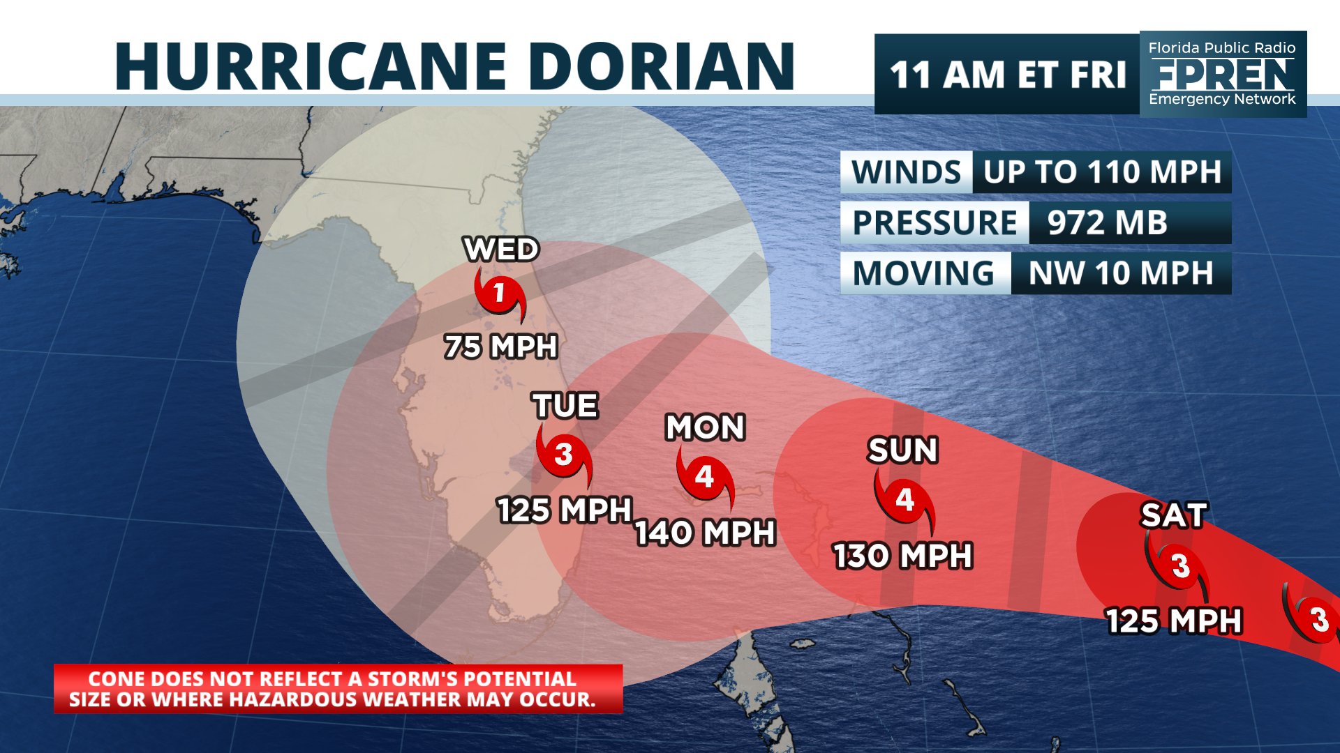
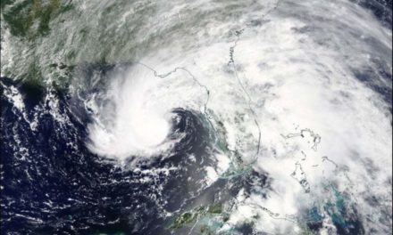
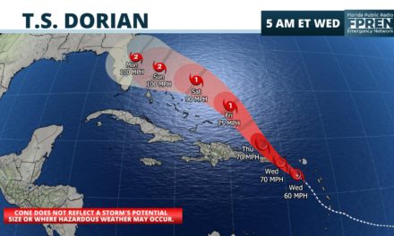
At 1100 AM AST (1500 UTC), the eye of Hurricane Dorian was located
near latitude 24.5 North, longitude 69.8 West. Dorian is moving
toward the northwest near 10 mph (17 km/h). A slower west-
northwestward to westward motion should begin tonight and continue
into early next week. On this track, the core of Dorian should
move over the Atlantic well north of the southeastern and central
Bahamas today and tomorrow, be near or over the northwestern
Bahamas on Sunday, and be near the Florida peninsula late Monday.
Maximum sustained winds are near 110 mph (175 km/h) with higher
gusts. Dorian is expected to become a major hurricane later
today, and it will remain an extremely dangerous major hurricane
while it moves near the northwestern Bahamas and approaches the
Florida peninsula into early next week.
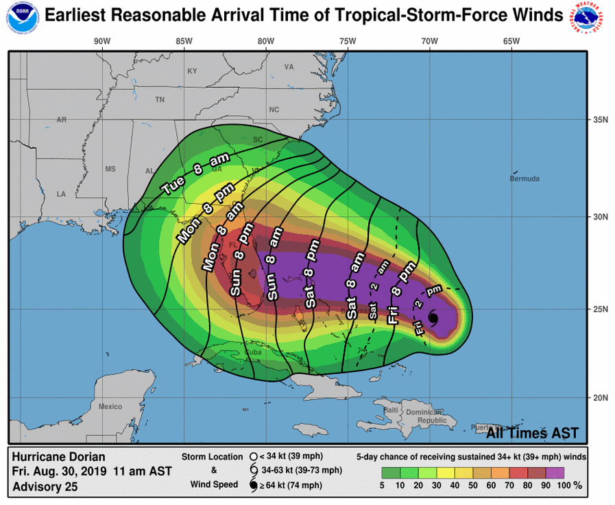
Hurricane-force winds extend outward up to 25 miles (35 km) from the
center and tropical-storm-force winds extend outward up to 105 miles
(165 km).
The estimated minimum central pressure from the NOAA and Air Force
reconnaissance planes is 972 mb (28.71 inches).
HAZARDS AFFECTING LAND
———————-
WIND: Hurricane conditions are possible in the northwestern
Bahamas by Sunday, with tropical storm conditions possible by
Saturday night or Sunday morning.
STORM SURGE: A life-threatening storm surge will raise water levels
by as much as 10 to 15 feet above normal tide levels in areas of
onshore winds in the northwestern Bahamas. Near the coast,the surge
will be accompanied by large and destructive waves.
RAINFALL: Dorian is expected to produce the following rainfall
accumulations this weekend into the middle of next week:
Northwestern Bahamas and coastal sections of the Southeast
United States…6 to 12 inches, isolated 18 inches.
Central Bahamas…1 to 2 inches, isolated 4 inches.
This rainfall may cause life-threatening flash floods.
SURF: Swells are likely to begin affecting the east-facing shores
of the Bahamas, the Florida east coast, and the southeastern United
States coast during the next few days. These swells are likely to
cause life-threatening surf and rip current conditions. Please
consult products from your local weather office.
NEXT ADVISORY
————-
Next intermediate advisory at 200 PM AST.
Next complete advisory at 500 PM AST.
$$
Forecaster Avila
National Hurricane Center
Hurricane Dorian Discussion Number 25
Hurricane Dorian Discussion Number 25
NWS National Hurricane Center Miami FL AL052019
1100 AM AST Fri Aug 30 2019
Both Air Force and NOAA aircraft have been sending data from Dorian
this morning. The flight-level winds from both planes have peaks
at 100 kt and the SFMR measured 94 kt. The minimum central pressure
has been oscillating between 972 and 976 mb. On this basis, the
initial intensity has been set to 95 kt. The upper-low currently
over Cuba which has been inducing some shear over Dorian is moving
away from the hurricane, and the upper-level flow pattern is
evolving toward a more favorable environment. In fact, the eye is
becoming apparent on visible images as we speak and in radar data
from the NOAA P3 aircraft. Consequently, the NHC forecast calls for
additional intensification, and Dorian is expected to become an
extremely dangerous major hurricane soon with additional
strengthening likely as it heads for the northwestern Bahamas and
the Florida peninsula.
Fixes from both reconnaissance planes indicate that Dorian is moving
toward the northwest of 310 degrees at 9 kt. As the upper-low over
Cuba moves westward and a strong subtropical ridge builds over the
western Atlantic as indicated by global models, the hurricane should
be forced to turn west-northwestward and westward on a track toward
the northwestern Bahamas and the Florida peninsula. By the end of
the forecast period, the ridge is forecast to erode and the
steering currents will weaken, resulting in Dorian slowing down
considerably near and over the Florida peninsula. This increases
the uncertainty in the track forecast during the 4- to -5 day
period, and also will lead to a prolonged duration of wind,
storm surge, and rainfall. The official forecast has been very
consistent so far, and this one is very similar to the previous
NHC forecast. It follows the multi-model and corrected consensus,
and is in the middle of the guidance envelope.
Key Messages:
1. Life-threatening storm surge and devastating hurricane-force
winds are likely in portions of the northwestern Bahamas, where a
hurricane watch is in effect. Residents should execute their
hurricane plan and listen to advice given by local emergency
officials.
2. Life-threatening storm surge and devastating hurricane-force
winds are likely along portions of the Florida east coast by early
next week, but it is too soon to determine where the highest storm
surge and winds will occur. Residents should have their hurricane
plan in place, know if they are in a hurricane evacuation zone, and
listen to advice given by local emergency officials.
3. A prolonged period of storm surge, high winds and rainfall is
likely in portions of Florida into next week, including the
possibility of hurricane-force winds over inland portions of the
Florida peninsula.
4. Heavy rains are expected over portions of the Bahamas, Florida,
and elsewhere in the southeastern United States this weekend into
the middle of next week.
FORECAST POSITIONS AND MAX WINDS
INIT 30/1500Z 24.5N 69.8W 95 KT 110 MPH
12H 31/0000Z 25.3N 71.0W 105 KT 120 MPH
24H 31/1200Z 25.9N 72.7W 110 KT 125 MPH
36H 01/0000Z 26.3N 74.5W 115 KT 130 MPH
48H 01/1200Z 26.6N 76.1W 115 KT 130 MPH
72H 02/1200Z 26.8N 78.6W 120 KT 140 MPH
96H 03/1200Z 27.0N 80.4W 110 KT 125 MPH…INLAND
120H 04/1200Z 29.0N 81.5W 65 KT 75 MPH…INLAND
$$
Forecaster Avila
