
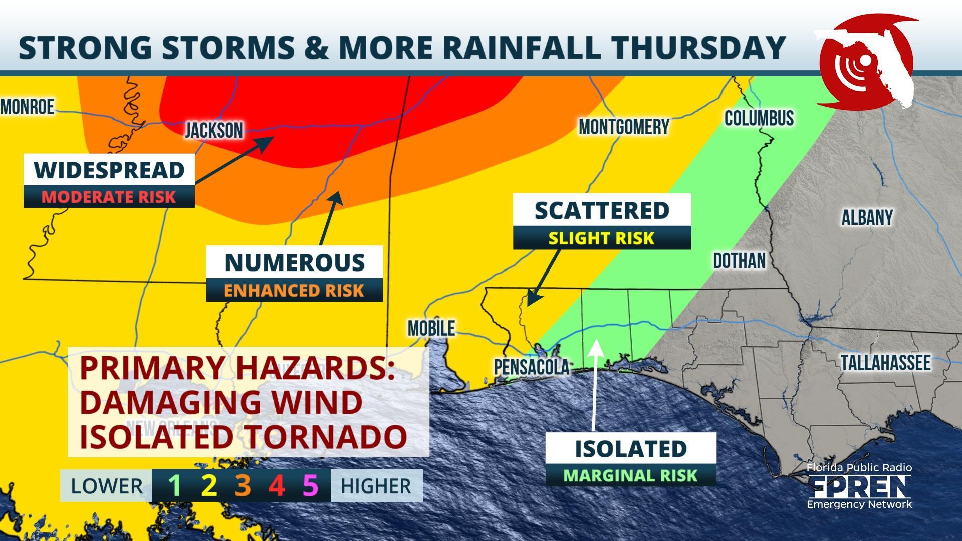
Gainesville, Florida – A second wave of active weather is expected to move through already saturated portions of the Florida Panhandle Thursday. Scattered downpours will continue to increase the flood threat but a few strong storms could produce damaging wind gusts, hail, and isolated tornadoes.
A strengthening low pressure system and cold front over the Plains Wednesday was continuing to slide eastward towards the lower Mississippi River Valley. Ahead of the low pressure system a warm front will begin to lift northward from the Gulf of Mexico overnight Wednesday and into Thursday. Strong high-altitude winds are forecast to overspread the western Florida Panhandle Thursday afternoon and into the evening above an increasingly humid and unstable atmosphere as the warm front lifts northward, trapping the western Panhandle between the cold and warm front boundaries — a section known as the ‘warm sector’.
The Storm Prediction Center Wednesday increased the severe weather potential risk for parts of the Deep South. Some of the same areas which saw heavy damage from the St. Patrick’s Day severe weather event last week could experience a similar repeat. A Moderate Risk (hazard level 4 out of 5) was issued for parts of Mississippi, Alabama and Tennessee ahead of Thursday’s event. The hazard level decreases towards the Gulf coast but the chance of a few scattered strong storms will remain. A Slight Risk (hazard level 2 out of 5) is in place for extreme northwestern locations of the Florida Panhandle. The cities of Pensacola, Crestview and Destin are outlined in the lowest risk level, Marginal.
While the greatest threat will likely remain to the north and west of the Panhandle, conditions are expected to remain conducive for a few strong to severe thunderstorms, some of which could produce isolated tornadoes, hail, and damaging straight-line winds. The flash flooding threat will continue to remain the main concern for the Florida Panhandle through the end of the work week.
Estimated rainfall totals between 5 and 10 inches will be possible through Friday according to the National Weather Service. The highest rainfall amounts are likely to take place in Escambia and Santa Rosa counties, and westward along the Alabama, Mississippi, and Louisiana Gulf coasts. Rainfall amounts of 1 to 3 inches are likely as far east as Fort Walton, Destin, Miramar, Crestview, and Defuniak Springs.
A Flash Flood Watch remains for Escambia and Santa Rosa counties until Friday morning. The Flash Flood Watch means that the ingredients for flash flooding, such as repeated heavy rainfall from slow-moving thunderstorms, may come together over a large area. Not all areas will experience flash flooding.
The western Panhandle should receive a small window of drier conditions beginning Friday before another potential storm system moves in for the end of the weekend. This final system should be fast moving limiting additional rainfall accumulations.
Story by FPREN Dr. Athena Masson.

