
FPREN HQ – Tuesday marked the historical peak of the Atlantic hurricane season, and we are monitoring three areas of interest for possible development. However, none of them are an immediate or significant threat to Florida.
We’ve included the official National Hurricane Center 5-day outlook in the section below, immediately followed by a summary of all three systems.
Tropical Storm Development Possible in Gulf of Mexico
National Hurricane Center - Tropical Weather Outlook
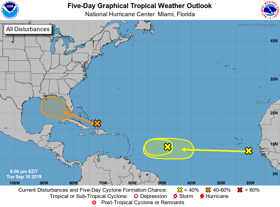
Tropical Weather Outlook_NHC_8pm_9_10_19
Tropical Weather Outlook
NWS National Hurricane Center Miami FL
800 PM EDT Tue Sep 10 2019
For the North Atlantic…Caribbean Sea and the Gulf of Mexico:
1. A surface trough located over the Turks and Caicos is producing
widespread cloudiness and disorganized thunderstorms over the Turks
and Caicos and the southeastern Bahamas, and extending northward
over the southwestern Atlantic for a few hundred miles. Ship reports
indicate that tropical-storm-force wind gusts are occurring in some
of the heavier squalls. Limited development of this disturbance is
expected during the next few days while the system moves slowly
west-northwestward across the Bahamas due to only marginally
conducive upper-level winds. However, environmental conditions could
become more favorable for development when the system moves over the
Florida Straits and into the eastern Gulf of Mexico late this week
and over the weekend. Regardless of development, this disturbance
will produce periods of locally heavy rainfall and gusty winds
across the Bahamas through Thursday, and across Florida on Friday
and continuing into the weekend.
* Formation chance through 48 hours…low…10 percent.
* Formation chance through 5 days…medium…40 percent.
2. A broad low pressure system, associated with a tropical wave, is
located about 900 miles east of the Lesser Antilles. Although this
disturbance continues to produce disorganized shower activity,
some slight development of this system is still possible tonight and
Wednesday. By Thursday, however, upper-level winds are forecast to
become unfavorable for tropical cyclone formation. This disturbance
is expected to move slowly westward across the tropical Atlantic
Ocean for the next several days.
* Formation chance through 48 hours…low…20 percent.
* Formation chance through 5 days…low…20 percent.
3. A tropical wave located between the west coast of Africa and the
Cabo Verde Islands is expected to move quickly westward during the
next several days. Some slow development is possible over the
weekend when the system is a few hundred miles east of the Windward
Islands.
* Formation chance through 48 hours…low…near 0 percent.
* Formation chance through 5 days…low…20 percent.
Forecaster Stewart
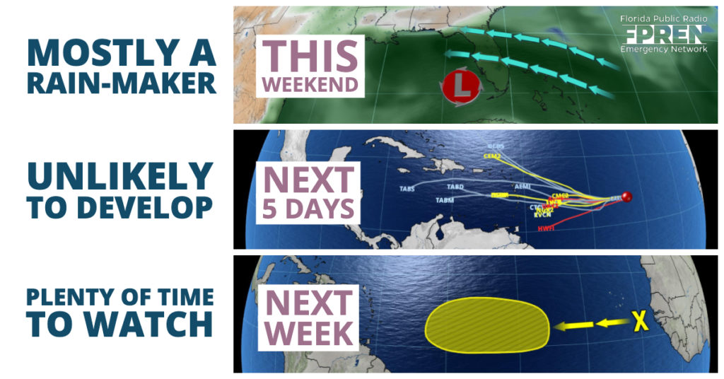
System Near Bahamas
An area of low pressure moving through the southern Bahamas is likely to bring periods of heavy rain to portions of Florida by the end of the week. Forecasters at the National Hurricane Center consider the chances of tropical development to be “low”, and only after the disturbance moves through the Florida Straits and into the Gulf of Mexico this weekend. Regardless, a stream of tropical moisture on the system’s eastern side will likely be pulled across the peninsula and produce numerous rounds of rain, some of it possibly heavy.
Weak Tropical Wave
A tropical wave in the central Atlantic is also unlikely to develop over the next five days, primarily due to strong winds aloft preventing it from becoming better organized. Forecast data suggests the disturbance will move into the eastern Caribbean this weekend and likely dissipate entirely.
Stronger Wave Farther Out
A strong tropical wave is on track to move off the west coast of Africa Wednesday, and this one might have the greatest chance of developing. Several forecast models are signaling favorable atmospheric conditions over the Atlantic Ocean in about a week, or roughly the time the wave is likely to be approaching the Lesser Antilles. There is little to no credibility in forecasting the track or strength of tropical weather systems beyond 5 to 7 days, so all Floridians are encouraged to stay informed and check in with us often over the coming days.
Story by Florida Public Radio Emergency Network
Expires at 2:00pm on Wednesday September 11th, 2019
