
National Hurricane Center
Tropical Weather Outlook
Tropical Weather Outlook
NWS National Hurricane Center Miami FL
800 PM EDT Tue Sep 3 2019
For the North Atlantic…Caribbean Sea and the Gulf of Mexico:
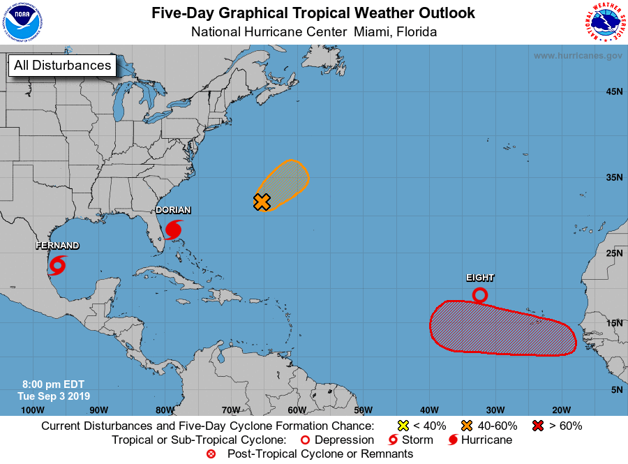
The National Hurricane Center is issuing advisories on Hurricane
Dorian, located east of Melbourne, Florida. The National
Hurricane Center is also issuing advisories on recently upgraded
Tropical Storm Fernand, located over the southwestern Gulf of
Mexico, and on recently formed Tropical Depression Eight, located
several hundred miles west-northwest of the Cabo Verde Islands.
1. A trough of low pressure, located just west of Bermuda, is producing
disorganized showers and thunderstorms. Some development of this
disturbance is possible, and a tropical depression could form
during the next couple of days as the disturbance moves northeast,
away from Bermuda. Afterward, upper-level winds are forecast to
become less favorable for tropical cyclone formation. Interests in
Bermuda should monitor the progress of this system, and areas of
heavy rainfall are likely.
* Formation chance through 48 hours…medium…50 percent.
* Formation chance through 5 days…medium…50 percent.
2. A tropical wave is forecast to emerge over the far eastern tropical
Atlantic between Africa and the Cabo Verde Islands within the next
day or so. Environmental conditions are forecast to be conducive
for development, and a tropical depression is likely to form late
this week or over the weekend while the system moves westward to
west-northwestward.
* Formation chance through 48 hours…low…near 0 percent.
* Formation chance through 5 days…high…70 percent.
Public Advisories on Tropical Depression Eight are issued under WMO
header WTNT33 KNHC and under AWIPS header MIATCPAT3.
Forecast/Advisories on Tropical Depression Eight are issued under
WMO header WTNT23 KNHC and under AWIPS header MIATCMAT3.
Forecaster Latto
Panama City, Florida – All eyes were to the Bahamas over the weekend and labor day as Hurricane Dorian become one of the strongest storms in the Atlantic record books, peaking with 185mph winds in the northern Bahama Islands. The system has caused lost of life according to the Bahamian Government, as well as catastrophic destruction in the northern islands.
Rescue missions are underway as the storm surge and winds have finally begin to subside. There are unofficial reports of storm surge near 20ft, and the town of Freeport, Grande Bahama was nearly underwater as Dorian spun over the island for nearly 24 hours. Videos being posted online by rescue teams doing flyovers for search and rescue, show many areas destroyed or underwater. The International Airport posted images showing that all of the airport was under water at one point, nearly 10 feet deep in some areas. To read more about the rescue efforts, visit NPR online.
As we begin to head into the peak of the Atlantic Hurricane season, the National Hurricane Center says it is monitoring several systems in the Atlantic basin. The National Hurricane Center is issuing advisories on Hurricane Dorian, located east of Melbourne, Florida as of Tuesday evening. The system is forecast to hug the SE coast over next few day before heading into the North Atlantic. The National Hurricane Center is also issuing advisories on recently upgraded Tropical Storm Fernand, located over the southwestern Gulf of Mexico, which is expected to go ashore in Mexico in the next 24 hours. Then out in the far Atlantic the National Hurricane Center has said a tropical wave has recently formed into Tropical Depression Eight, located several hundred miles west-northwest of the Cabo Verde Islands.
As a reminder from the WKGC Storm Center, download the Florida Storms App to get valuable information for Hurricane Season, as well as staying connected to WKGC.
