
FPREN HQ – A significant change in the weather pattern that is steering Dorian may lessen the impacts of the hurricane over parts of the state. Forecasters warn; however, that heavy rain, strong winds, and coastal flooding are still likely along the east coast of Florida even if the hurricane does not make landfall. High surf and rip currents are expected this weekend into early next week.
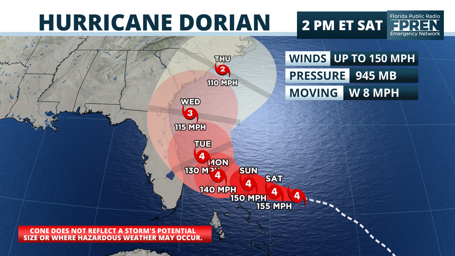
The storm rapidly intensified Friday evening into an extremely powerful category 4 hurricane. Seasonably warm ocean temperatures and light wind shear — both of which are normally needed for intense hurricanes — are expected to fuel the storm for several more days.
A ridge of high pressure that is steering the Dorian is forecast to keep pushing it westward this weekend toward the northwestern Bahamas. The ridge; however, is now forecast to be much weaker by Monday, which will cause it to slow or stall just offshore of Florida Monday. A turn toward the north is likely Tuesday and Wednesday.
Tropical storm force winds are expected to reach parts of South Florida and the Space Coast on Monday, gradually spreading toward Daytona Beach and the First Coast on Tuesday. Hurricane force winds are becoming less likely, but are still possible if the storm takes a closer track to Florida.
Coastal flooding is likely, regardless of how close Dorian gets to the state. The new moon is causing high astronomical tides during the times of high tide. The National Weather Service in Jacksonville has issued Coastal Flood Advisories. Tidal departures may reach 1 to 2 feet above normal this weekend.
Story by FPREN Meteorologist Ray Hawthorne
National Hurricane Center
Hurricane Dorian Discussion Number 29
Hurricane Dorian Discussion Number 29
NWS National Hurricane Center Miami FL AL052019
1100 AM EDT Sat Aug 31 2019
Dorian’s satellite presentation is outstanding with a distinct eye
of about 15 n mi in diameter. Both NOAA and Air Force Hurricane
Hunter planes have been penetrating the eye this morning and based
on a blend of the flight-level and SFMR winds, the initial intensity
has been adjusted upward to 130 kt in this advisory. Dorian is
forecast to move over a deep layer of very warm waters, which is
like high octane-fuel for hurricanes. The combination of the warm
ocean and the prevailing low shear along Dorian’s path should favor
some additional strengthening, but most likely the hurricane will
experience some fluctuations in intensity due to eyewall replacement
cycles that are difficult to predict. Beyond 3 days, as the
hurricane begins to gain in latitude a gradual weakening is
anticipated.
Plane fixes indicate that Dorian is moving toward the west or 280
degrees at 7 kt, steered by weak flow to the south of the ridge
of high pressure over the western Atlantic. Most of the global
models shift the high eastward and deepens a trough over the
eastern United States beyond 2 days. This steering flow would
typically favor a gradual turn of the hurricane to the northwest and
north, however there is large uncertainty in the exact location
and timing of this northward turn. Although the latest guidance
has shifted a little bit eastward again this morning, there are
still ECMWF and GFS ensemble members that do not forecast the
northward turn so soon. On this basis, NHC prefers to shift the
track forecast just a little bit to the right of the previous one,
and the new official forecast lies along the western edge of the
guidance envelope. This will allow for further adjustments in the
track during future forecast cycles.
Key Messages:
1. A prolonged period of life-threatening storm surge and
devastating hurricane-force winds are expected in portions of the
northwestern Bahamas, particularly on the Abaco Islands and Grand
Bahama Island. A hurricane warning is in effect for these areas,
and residents should listen to advice given by local emergency
officials and have their hurricane preparations completed today.
2. Life-threatening storm surge and dangerous hurricane-force winds
are still possible along portions of the Florida east coast by the
early to middle part of next week, but since Dorian is forecast to
slow down and turn northward near or just offshore of the coast, it
is too soon to determine when or where the highest surge and winds
could occur. Residents should have their hurricane plan in place,
know if they are in a hurricane evacuation zone, and listen to
advice given by local emergency officials.
3. The risk of strong winds and dangerous storm surge is increasing
along the coasts of Georgia, South Carolina, and North Carolina
during the middle of next week. Residents in these areas should
continue to monitor the progress of Dorian.
4. Heavy rains, capable of life-threatening flash floods, are
expected over portions of the Bahamas and coastal sections of the
southeastern United States this weekend through much of next week.
FORECAST POSITIONS AND MAX WINDS
INIT 31/1500Z 26.0N 73.4W 130 KT 150 MPH
12H 01/0000Z 26.2N 74.7W 135 KT 155 MPH
24H 01/1200Z 26.6N 76.2W 130 KT 150 MPH
36H 02/0000Z 26.8N 77.4W 125 KT 145 MPH
48H 02/1200Z 27.0N 78.0W 120 KT 140 MPH
72H 03/1200Z 28.0N 79.0W 115 KT 130 MPH
96H 04/1200Z 30.5N 80.0W 100 KT 115 MPH
120H 05/1200Z 33.5N 78.0W 95 KT 110 MPH
$$
Forecaster Avila
