
Hurricane Dorian Advisory Number 26
NWS National Hurricane Center Miami FL AL052019
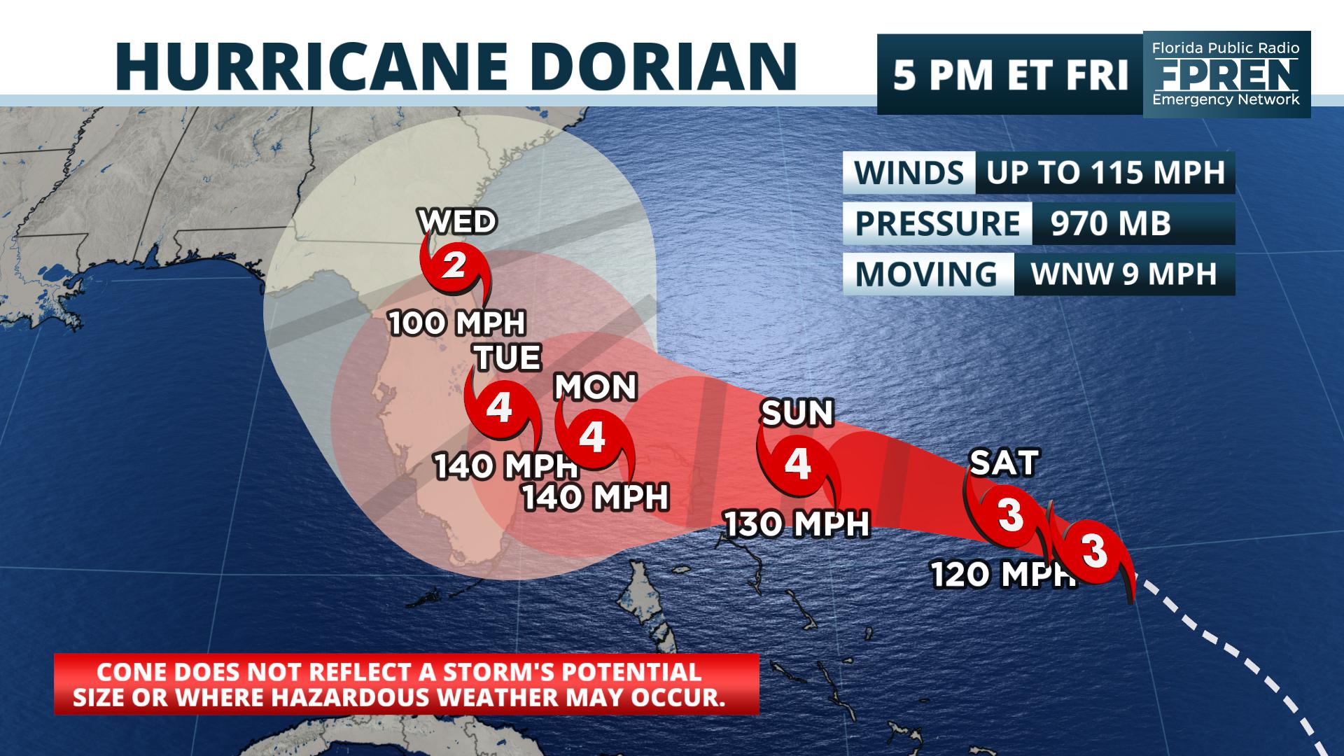
500 PM EDT Fri Aug 30 2019
…EXTREMELY DANGEROUS HURRICANE DORIAN HEADING FOR THE NORTHWESTERN
BAHAMAS…
…HURRICANE WARNING ISSUED FOR THE NORTHWESTERN BAHAMAS…
SUMMARY OF 500 PM EDT…2100 UTC…INFORMATION
———————————————-
LOCATION…25.0N 70.7W
ABOUT 420 MI…675 KM E OF THE NORTHWESTERN BAHAMAS
ABOUT 595 MI…960 KM E OF WEST PALM BEACH FLORIDA
MAXIMUM SUSTAINED WINDS…115 MPH…185 KM/H
PRESENT MOVEMENT…WNW OR 300 DEGREES AT 9 MPH…15 KM/H
MINIMUM CENTRAL PRESSURE…970 MB…28.65 INCHES
WATCHES AND WARNINGS
——————–
CHANGES WITH THIS ADVISORY:
The government of the Bahamas has issued a Hurricane Warning
for the northwestern Bahamas, including the Abacos, Berry Islands,
Bimini, Eleuthera, Grand Bahama Island, and New Providence.
SUMMARY OF WATCHES AND WARNINGS IN EFFECT:
A Hurricane Warning is in effect for…
* Northwestern Bahamas excluding Andros Island
A Hurricane Watch is in effect for…
* Andros Island
A Hurricane Warning means that hurricane conditions are expected
somewhere within the warning area. A warning is typically issued
36 hours before the anticipated first occurrence of tropical-storm-
force winds, conditions that make outside preparations difficult or
dangerous. Preparations to protect life and property should be
rushed to completion.
A Hurricane Watch means that hurricane conditions are possible
within the watch area. A watch is typically issued 48 hours before
the anticipated first occurrence of tropical-storm-force winds,
conditions that make outside preparations difficult or dangerous.
Interests in southern and central Florida should monitor the
progress of Dorian.
For storm information specific to your area, please monitor
products issued by your national meteorological service.
DISCUSSION AND OUTLOOK
———————-
At 500 PM EDT (2100 UTC), the well-defined eye of Hurricane Dorian
was located near latitude 25.0 North, longitude 70.7 West. Dorian is
moving toward the west-northwest near 9 mph (15 km/h). A slower
west-northwestward to westward motion should begin tonight and
continue into early next week. On this track, the core of Dorian
should move over the Atlantic well north of the southeastern and
central Bahamas tonight and tomorrow, be near or over the
northwestern Bahamas on Sunday, and be near the Florida east coast
late Monday.
Maximum sustained winds are near 115 mph (185 km/h) with higher
gusts. Dorian is a category 3 hurricane on the Saffir-Simpson
Hurricane Wind Scale. Additional strengthening is forecast, and
Dorian is anticipated to remain an extremely dangerous hurricane
while it moves near the northwestern Bahamas and approaches the
Florida peninsula into early next week.
Hurricane-force winds extend outward up to 30 miles (45 km) from the
center and tropical-storm-force winds extend outward up to 115 miles
(185 km).
The estimated minimum central pressure is 970 mb (28.65 inches).
HAZARDS AFFECTING LAND
———————-
WIND: Hurricane conditions are expected in the hurricane warning
area in the northwestern Bahamas by Sunday, with tropical storm
winds beginning by Saturday night.
STORM SURGE: A life-threatening storm surge will raise water levels
by as much as 10 to 15 feet above normal tide levels in areas of
onshore winds in the northwestern Bahamas. Near the coast,the surge
will be accompanied by large and destructive waves.
RAINFALL: Dorian is expected to produce the following rainfall
accumulations this weekend into the middle of next week:
Northwestern Bahamas…10 to 15 inches, isolated 20 inches.
Coastal sections of the southeast United States…6 to 12 inches,
isolated 18 inches.
Central Bahamas…2 to 4 inches, isolated 6 inches.
This rainfall may cause life-threatening flash floods.
SURF: Swells are likely to begin affecting the east-facing shores
of the Bahamas, the Florida east coast, and the southeastern United
States coast during the next few days. These swells are likely to
cause life-threatening surf and rip current conditions. Please
consult products from your local weather office.
NEXT ADVISORY
————-
Next intermediate advisory at 800 PM EDT.
Next complete advisory at 1100 PM EDT.
$$
Forecaster Avila
National Hurricane Center
Hurricane Dorian Discussion Number 26
Hurricane Dorian Discussion Number 26
NWS National Hurricane Center Miami FL AL052019
500 PM EDT Fri Aug 30 2019
High resolution satellite images show that Dorian’s cloud pattern
has become much better organized, with a distinct eye surrounded by
a ring of very deep convection and fair upper-level outflow.
Satellite intensity estimates, both objectivs from CIMMS and
subjective from TAFB and SAB, are in good agreement with the 100-kt
winds recently measured by a reconnaissance aircraft. This is the
intensity assigned to Dorian in this advisory.
Since the upper-level environment is already becoming more favorable
for intensification and Dorian will be over high sea surface
temperatures, the NHC forecast calls for additional intensification.
Dorian is expected to be an extremely dangerous major hurricane as
it moves through the northwestern Bahamas and near the east coast of
the Florida peninsula in about 2 to 4 days.
The ridge over the western Atlantic appears to be already building
to the north of Dorian and is beginning to force the hurricane on a
more west-northwest track or 300 degrees at 9 kt. The ridge is
forecast to build even more and steer Dorian on a westward track for
the next 3 to 4 days. However, the steering currents will then
weaken, and this should result in a decrease in the hurricane’s
forward speed. Given the collapse of the steering currents, the
track forecast by the end of the forecast period is highly
uncertain, and any small deviation in the track could bring the
core of the powerful hurricane well inland over the Florida, keep
it near the coast, or offshore. The models have not been very
consistent from run to run in terms of the timing of the northward
turn, but there are more models now indicating that the turn could
occur near the east coast of Florida instead of well inland. Given
this latest change, the NHC forecast has been shifted just a little
to the right at this time, but users should be prepared for
additional adjustements to the left or right depending on future
model trends.
Based on the new forecast, a hurricane warning has been issued for
poertions of the northwest Bahamas. However, given the slower
forecast speed of Dorian, it is too soon to issue and watches for
the Florida coast at this time.
Key Messages:
1. Life-threatening storm surge and devastating hurricane-force
winds are likely in portions of the northwestern Bahamas, where a
hurricane warning is in effect. Residents should execute their
hurricane plan and listen to advice given by local emergency
officials.
2. Life-threatening storm surge and devastating hurricane-force
winds are likely along portions of the Florida east coast by early
next week, but since Dorian is forecast to slow down and turn
northward near the coast, it is too soon to determine when or where
the highest surge and winds will occur. Residents should have their
hurricane plan in place, know if they are in a hurricane evacuation
zone, and listen to advice given by local emergency officials.
3. A prolonged period of storm surge, high winds and rainfall is
possible in portions of Florida into next week, including the
possibility of hurricane-force winds over inland portions of the
Florida peninsula.
4. Heavy rains, capable of life-threatening flash floods, are
expected over portions of the Bahamas and coastal sections of the
southeastern United States this weekend through much of next week.
FORECAST POSITIONS AND MAX WINDS
INIT 30/2100Z 25.0N 70.7W 100 KT 115 MPH
12H 31/0600Z 25.6N 72.0W 105 KT 120 MPH
24H 31/1800Z 26.2N 73.8W 110 KT 125 MPH
36H 01/0600Z 26.5N 75.4W 115 KT 130 MPH
48H 01/1800Z 26.8N 76.9W 120 KT 140 MPH
72H 02/1800Z 27.0N 78.8W 120 KT 140 MPH
96H 03/1800Z 27.5N 80.4W 120 KT 140 MPH…NEAR FL EAST COAST
120H 04/1800Z 30.0N 81.5W 85 KT 100 MPH…INLAND
$$
Forecaster Avila


