
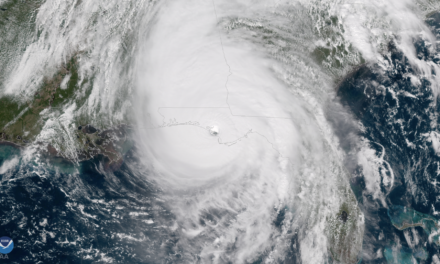
Hurricane Dorian Advisory Number 19
NWS National Hurricane Center Miami FL AL052019
1100 PM AST Wed Aug 28 2019
…HURRICANE HUNTERS FIND DORIAN STRENGTHENING…
SUMMARY OF 1100 PM AST…0300 UTC…INFORMATION
———————————————–
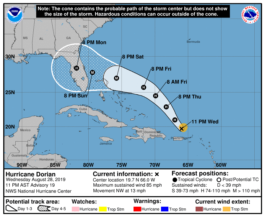
LOCATION…19.7N 66.0W
ABOUT 90 MI…145 KM N OF SAN JUAN PUERTO RICO
MAXIMUM SUSTAINED WINDS…85 MPH…140 KM/H
PRESENT MOVEMENT…NW OR 320 DEGREES AT 13 MPH…20 KM/H
MINIMUM CENTRAL PRESSURE…986 MB…29.12 INCHES
WATCHES AND WARNINGS
——————–
There are no coastal watches or warnings in effect.
DISCUSSION AND OUTLOOK
———————-
At 1100 PM AST (0300 UTC), the center of Hurricane Dorian was
located near latitude 19.7 North, longitude 66.0 West. Dorian is
moving toward the northwest near 13 mph (20 km/h), and this general
motion is expected to continue through Friday. On this track,
Dorian should move over the Atlantic well east of the southeastern
and central Bahamas on Thursday and Friday.
Maximum sustained winds have increased to near 85 mph (140 km/h)
with higher gusts. Dorian is forecast to strengthen into a
powerful hurricane during the next couple of days.
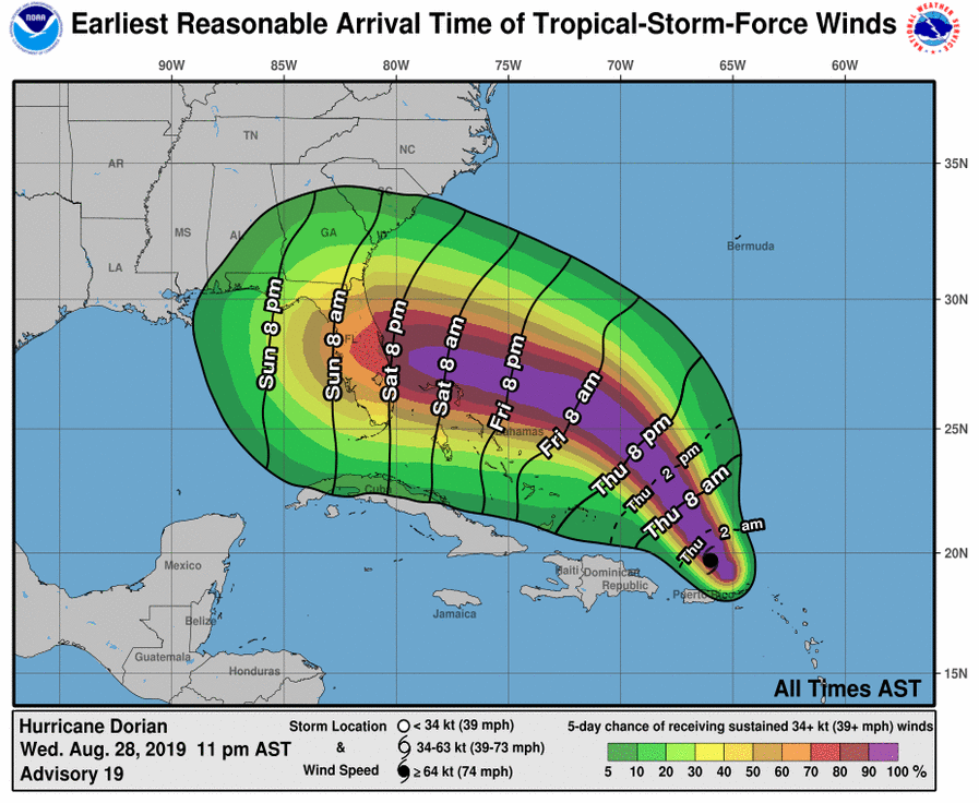
Hurricane-force winds extend outward up to 15 miles (30 km) from the
center, and tropical-storm-force winds extend outward up to 70 miles
(110 km).
The minimum central pressure estimated from Hurricane Hunter
observations is 986 mb (29.12 inches).
HAZARDS AFFECTING LAND
———————-
RAINFALL: Dorian is expected to produce the following rainfall
accumulations:
The central Bahamas…2 to 4 inches, isolated 6 inches.
The northern Bahamas and Coastal sections of the Southeast United
States…4 to 8 inches, isolated 10 inches.
This rainfall may cause life-threatening flash floods.
SURF: Swells around the U.S. and British Virgin Islands and
Puerto Rico should gradually diminish tonight.
NEXT ADVISORY
————-
Next complete advisory at 500 AM AST.
$$
Forecaster Pasch
National Hurricane Center
Hurricane Dorian Discussion Number 19
Hurricane Dorian Discussion Number 19
NWS National Hurricane Center Miami FL AL052019
1100 PM AST Wed Aug 28 2019
Data from an Air Force Reserve Unit Hurricane Hunter aircraft
indicate that Dorian has intensified, and San Juan radar data show
that the eye is becoming better defined. Based on SFMR-observed
surface wind observations from the aircraft, the intensity is
increased to 75 kt. Dorian should remain in an environment of low
shear, within a moistening mid-level air mass, and over SSTs near 29
deg C for the next several days. This should allow for Dorian to
intensify into a major hurricane. The official intensity forecast
is similar to the previous one, and close to the latest DSHIPS model
output.
The initial motion estimate remains northwestward, or 320/11 kt.
Dorian should continue to move northwestward toward a weakness in
the subtropical ridge over the next couple of days. Later in the
forecast period, a ridge builds over the western Atlantic. This
evolution of the steering pattern should cause Dorian to turn
west-northwestward and head for the Florida peninsula. The actual
track of the hurricane in 3 to 5 days will depend on how much the
western Atlantic ridge builds during that time frame. This is, of
course, subject to uncertainty. The official track forecast is very
similar to the previous one, and close to the latest simple and
corrected dynamical model consensus.
Key Messages:
1. The risk of dangerous storm surge and hurricane-force winds later
this week and this weekend continues to increase in the central and
northwestern Bahamas and along the Florida east coast, although it
is too soon to determine where these hazards will occur. Residents
in these areas should ensure they have their hurricane plan in place
and not focus on the exact forecast track of Dorian’s center.
2. Heavy rains are expected to occur over portions of the Bahamas,
Florida, and elsewhere in the southeastern United States later this
week and into early next week.
FORECAST POSITIONS AND MAX WINDS
INIT 29/0300Z 19.7N 66.0W 75 KT 85 MPH
12H 29/1200Z 21.0N 67.0W 80 KT 90 MPH
24H 30/0000Z 22.9N 68.3W 85 KT 100 MPH
36H 30/1200Z 24.5N 69.9W 90 KT 105 MPH
48H 31/0000Z 25.7N 71.7W 95 KT 110 MPH
72H 01/0000Z 27.0N 75.8W 100 KT 115 MPH
96H 02/0000Z 27.8N 79.4W 100 KT 115 MPH
120H 03/0000Z 28.4N 81.8W 80 KT 90 MPH…INLAND
$$
Forecaster Pasch
