
Panama City, Florida – There is slight chance of Tropical Cyclone Formation in the northern Gulf of Mexico, or off the Southeastern U.S. coast late next week into the weekend, (July 10-16th). That is according to meteorologists with the Climate Prediction Center, which is a part of the the National Weather Service, under NOAA, as they have released online their weekly update.
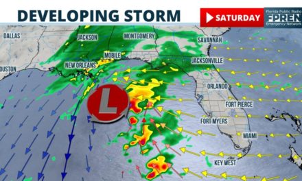
According to the July 5th, 2019 Global Tropics Hazards and Benefits Outlook, they have highlighted an area from Louisiana, to the South Carolina coast line as an area of possible tropical cyclone formation: (see image below)
“A stalled frontal zone over the Southeast CONUS may serve as a breeding ground for tropical cyclogenesis over the northeastern Gulf of Mexico or just off the Southeast Coast. Recent runs of the ECMWF high-resolution model are especially bullish, though there is also a developing signal in recent runs of the GEFS.“
There is an increased chance of tropical cyclone formation near the Southeast U.S. late next week. Updated GTH outlook: https://t.co/g3L6WzRkZq pic.twitter.com/z2C837IjKL
— NWSCPC (@NWSCPC) July 5, 2019
From the National Weather Service Office in Tallahassee, Florida that is responsible for the NW Florida area.
“The uncertainty increases Thursday and Friday as this trough moves southward over the Gulf of Mexico. While there has been a signal in the ECENS and GEFS for low pressure development, the 12Z/04 deterministic ECMWF and GFS have picked up on this, continuing with the latest 00Z/05 model suite. While it`s too early to speculate on any tropical development, given the proximity to land, we will be closely monitoring this. What we can say is that the signal is there for heavy rainfall over the gulf, which may propagate into nearby coastal areas.” (read more in area forecast discussion below)
National Weather Service Discussion from Tallahassee
Area Forecast Discussion - NWS TAE - 205 PM EDT Fri Jul 5 2019
Area Forecast Discussion
National Weather Service Tallahassee FL
205 PM EDT Fri Jul 5 2019

.AVIATION...
[Through 18Z Saturday]

VFR conditions prevail through the TAF period, however expect
scattered to widespread showers and thunderstorms through the rest
of the afternoon and into the evening hours before things begin to
quiet down after 00z. Stronger thunderstorms could bring limited
MVFR/IFR conditions for a brief time. Other aviation hazards
through the next 24 hours include the possibility for patchy fog
after 09z Saturday. This fog could bring conditions as low as
LIFR/IFR in spots, if it develops.

&&

.PREV DISCUSSION [1101 AM EDT]...

.NEAR TERM [Through Today]...

Deep layer ridging is forecast once again this afternoon, with a col
in the steering flow setting up across the Tri-State region. This
flow regime will result in a northerly flow component across
southeast Alabama and the Florida panhandle, and a southerly flow
component across the Big Bend and south Georgia. The result will be
two separate convective initiation patterns, eventually interacting
with each other. First, the Big Bend should expect an earlier start
to convection as the Gulf Coast seabreeze moves more freely inland
than yesterday afternoon. Mesoscale boundaries generated by early
afternoon storms will collide with the Atlantic Seabreeze across
south-central Georgia later in the afternoon for another focused
area of convection. Across the Panhandle, the northerly flow will
result in a later onset of seabreeze storms and will keep those
storms pinned mostly south of Interstate-10. However, southeast
Alabama and extreme southwest Georgia may get some late afternoon
storms along a moisture gradient in a convergent region, where some
drier air aloft is forecast to mix to the surface. In general, an
afternoon of numerous storms scattered about the region is expected.
A typical summertime threat for isolated to scattered storms capable
of producing strong wind gusts is expected today. Expect highs in
the mid to upper 90s along and west of a line from Apalachicola
through Albany where convection will get a later start, and the low
90s elsewhere. Heat indices are forecast to generally be in the 100-
105 degree range.


.SHORT TERM [Tonight Through Sunday]...

Overall, shower and thunderstorm coverage will be high on Saturday,
decreasing on Sunday, when advisory level heat is possible again.

Expect numerous showers and thunderstorms to develop once again
Saturday afternoon and evening. Despite a low to mid-level westerly
flow, the wind field is weak, which will allow the gulf and east
coast sea-breezes to penetrate well inland. In addition, a low
level trough across the area will also help focus activity. The
instability is near seasonal levels, but Precipitable Water values
are well above normal, just over 2.0 inches. Given the weak wind
field and numerous boundaries, slow moving activity will have
the potential to produce localized, poor drainage flooding. There
may be a tendency for less precip coverage west of the Flint and
Apalachicola Rivers, but given the uncertainty, will not introduce
lower precipitation potential just yet.

For Sunday, the trend is for the highest precipitation potential
to shift eastward into the FL Big Bend and I-75 corridor in GA,
as the aforementioned surface trough shifts east, while column
moisture decreases significantly to the west as a shortwave ridge
builds in aloft. The Galvez Davison Index, a measure of deep
convection, also supports this.

Heat index values decrease slightly on Saturday, but still 100-
105 degrees across much of the region, with spots in the Big Bend
near 108. The synoptic pattern may become more favorable for
widespread advisory level heat on Sunday, especially northwest
of the Big Bend, where less cloud cover/precip is expected.
Both WPC and CIPS Analogs Guidance are higher across this area.


.LONG TERM [Sunday Night Through Friday]...

The main concerns are increasing chances for heavy rainfall
near the Gulf coast on Thursday and Friday, and the potential
for advisory-level heat on Monday and Tuesday.

A persistent trough across the region and well above normal
Precipitable Water values leads to precip chances averaging
50-60 percent through at least Wednesday, above climatology.

The uncertainty increases Thursday and Friday as this trough
moves southward over the Gulf of Mexico. While there has been
a signal in the ECENS and GEFS for low pressure development,
the 12Z/04 deterministic ECMWF and GFS have picked up on this,
continuing with the latest 00Z/05 model suite. While it`s too
early to speculate on any tropical development, given the
proximity to land, we will be closely monitoring this. What
we can say is that the signal is there for heavy rainfall
over the gulf, which may propagate into nearby coastal areas.

As mentioned in the short term section, the synoptic pattern
and guidance from WPC and CIPS analogs indicates the potential
for advisory level heat across portions of the area on Monday
and Tuesday. However, this may be tempered by greater precip
potential, thus confidence in outcomes is low at this time.


.MARINE...

Tranquil boating conditions through Wednesday outside of mainly
overnight and morning thunderstorms, as well as slightly higher
winds in the sea-breeze zone, with winds mainly below 15 knots
and seas 2 feet or less. As a frontal boundary moves through the
waters on Thursday and Friday, the potential for more widespread
thunderstorms, as well elevated winds and seas will increase.


.FIRE WEATHER...

Red Flag conditions are not expected over the next several days.
Dispersion indices are forecast to be lower than usual across the
Big Bend and south Georgia this afternoon.


.HYDROLOGY...

A persistent, weak trough of low pressure across the region will
promote unseasonably high atmospheric moisture content. This
will enhance precipitation efficiency with afternoon and evening,
sea-breeze driven showers and thunderstorms through Wednesday.
The main impact will be localized, poor drainage flooding. On
Thursday and Friday into next weekend, a weak frontal boundary
will stall over the Gulf of Mexico. There is the potential for
heavy precipitation close to the gulf coast during this time
frame, but it`s to early to speculate further on amounts.


.SPOTTER INFORMATION STATEMENT...

Spotter activation is not requested. However, spotters are always
encouraged to safely report significant weather conditions when they
occur by calling the office or tweeting us @NWSTallahassee.

&&

.PRELIMINARY POINT TEMPS/POPS...

Tallahassee   74  90  73  94  75 /  40  70  30  40  50
Panama City   79  89  78  90  79 /  30  60  30  40  40
Dothan        75  94  75  94  75 /  40  60  20  50  40
Albany        75  92  74  94  75 /  50  70  20  50  40
Valdosta      72  89  72  93  74 /  50  70  20  50  40
Cross City    75  89  74  90  77 /  40  60  40  50  30
Apalachicola  77  88  77  91  79 /  40  60  40  40  40

&&

.TAE WATCHES/WARNINGS/ADVISORIES...
FL...None.
GA...None.
AL...None.
GM...None.
&&

$$

NEAR TERM...Harrigan
SHORT TERM...LF
LONG TERM...LF
AVIATION...Dobbs
MARINE...LF
FIRE WEATHER...Harrigan
HYDROLOGY...LF
This is a developing story…. more to follow from Florida Public Radio Emergency Network.
