
Gainesville, Florida – A non-tropical disturbance is expected to approach Florida Thursday and Friday, producing summer-like downpours and thunderstorms across much of the state.
If you're in a hurry...
- Low chance of development AFTER it brushes by Florida.
- Heavy rain risk highest eastern half of peninsula.
- The weekend will NOT be a washout.
A non-tropical disturbance is expected to approach Florida Thursday and Friday, producing summer-like downpours and thunderstorms across much of the state.
Read Official Outlook
TTAA00 KNHC DDHHMM
Special Tropical Weather Outlook
NWS National Hurricane Center Miami FL
925 AM EDT Wed May 1 2019
For the North Atlantic…Caribbean Sea and the Gulf of Mexico:
1. A trough of low pressure located over the northwestern Bahamas is
producing disorganized shower and thunderstorm activity. Little
development is expected during the next couple of days as the
system moves generally northwestward toward the Florida Peninsula.
Subsequently, some slow development is possible as the disturbance
turns northeastward and moves over the western Atlantic.
Regardless of development, locally heavy rains are possible over
portions of the Bahamas and the Florida Peninsula during the next
couple of days. The next Special Tropical Weather Outlook will be
issued by 10 AM EDT Thursday, or sooner if conditions warrant.
* Formation chance through 48 hours…low…near 0 percent.
* Formation chance through 5 days…low…20 percent.
Forecaster Beven
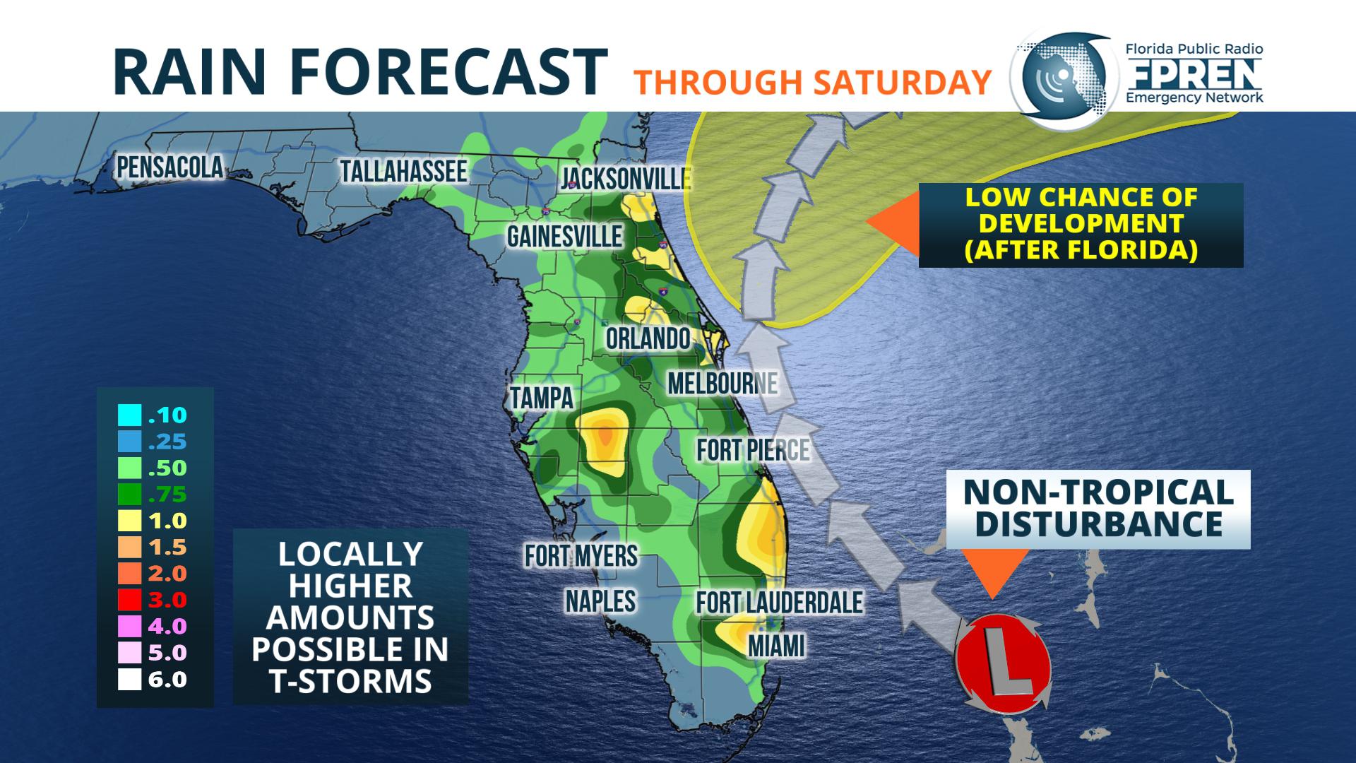
A cluster of thunderstorms associated with the system was noted on satellite near the Bahamas Wednesday morning, and showers were seen on radar already marching into portions of South Florida by early afternoon. In addition to the wet weather, the National Weather Service in Miami has advised that boating and swimming conditions will grow increasing hazardous over the next few days.
5/1 @ 10 am - A Disturbance now over the NW Bahamas will bring us heavy rainfall and hazardous swimming/boating conditions over the next few days. Flooding of poorly drained areas is possible. #flwx pic.twitter.com/mHWCuVItfm
— NWS Miami (@NWSMiami) May 1, 2019
The heaviest and most widespread rainfall near Miami, West Palm Beach and Fort Lauderdale will occur on Thursday, with wind gusts to 30 mph also possible at times. NOAA’s Weather Prediction Center says rainfall accumulations may exceed an inch in locations near and east of the I-95 corridor from Miami Beach to the Treasure Coast. Locally higher amounts are also possible from heavier thunderstorms.
Further west, from the Tampa metro to southwest Florida, showers and thunderstorms could become locally strong both Wednesday and Thursday afternoon due to the proximity of higher moisture and lift from the disturbance. A westward advancing sea breeze will enhance the activity, which will reach peak strength near the I-75 corridor before moving offshore into the Gulf of Mexico.
Showers will also develop over parts of central and north Florida Thursday afternoon. Another round of showers and thunderstorms is also likely Friday. This second round will be most concentrated in North Florida and may occur at any time during the day. The heaviest rain in these regions will likely occur near or east of the Florida Turnpike and I-75 corridors. Daytime heating and the interaction of a weak sea breeze may enhance the intensity and coverage of the activity in some locations.
Lighter amounts of rain are expected in the Florida Panhandle from this weather system, although scattered showers and thunderstorms are also possible, especially on Friday afternoon. Drier air is projected to sweep in the from the west and carry the deeper tropical moisture away from Florida on Saturday. However, an approaching front may increase the chances of showers and thunderstorms again by Sunday, particularly across the northern third of the state.
This post will expire at 6:00 pm on Thursday May 2nd, 2019
Story by Meteorologist Jeff Huffman of FPREN.
WKGC Public Radio is the local FPREN station in NW Florida.
